
Forecasters say temperatures are expected to be in the upper 40s Tuesday. Skies will become cloudy in the afternoon with the chance for a rain/snow mix developing in the afternoon and ending Wednesday morning.
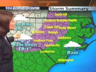
The heaviest precipitation and greatest chance of accumulation will be in the southern part of the state. Some isolated areas may see some accumulation of no more than an inch.
It will be a different story in western counties, where the the National Weather Service says significant snowfall is expected.
A winter storm warning is in effect for Avery, Haywood, Madison, Mitchell, Swain and Yancey counties until Wednesday morning. A winter storm watch is in effect for areas including Charlotte, Hickory, Shelby, Mocksville, Rutherfordton and Statesville.
The weather service has posted a winter weather advisory for Buncombe and northern Jackson counties.
The foothills and piedmont may see significant snowfall, which could linger into late Wednesday morning.
Copyright 2024 by WRAL.com and the Associated Press. All rights reserved. This material may not be published, broadcast, rewritten or redistributed.


