New satellites a 'game changer' in visualizing weather from space
Meteorologists at the National Hurricane Center and here at WRAL have been tracking Hurricane Florence from space since an unusual line of low pressure was first spotted off the African coast on Aug. 28. They have a new tool to help, and it is a game changer.
Posted — UpdatedMeteorologists at the National Hurricane Center and here at WRAL have been tracking Hurricane Florence from space since an unusual line of low pressure was first spotted off the African coast on Aug. 28. They have a new tool to help, and it is a game changer.
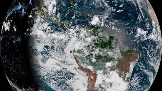
It orbits at a speed and direction which keeps it over the equator at 75.2° west longitude, 22,300 miles up. This provides a view of the Earth from pole to pole and from the west coast of Africa to the Hawaiian islands. Sister satellite GOES-17 was launched in March and covers out to Guam.
The ABI is flexible, allowing focus where the need is greatest. NOAA can shift into modes which increase the frequency of scans of from pole to pole, the continental United States (CONUS) or “mesoscale” areas like one covering the east coast from the Carolinas to Massachusetts. Several times each hour, the satellite recalibrates itself automatically by looking to the stars to confirm its position and orientation.
GOES-16 also hosts the first lightning mapper flown from geostationary orbit. It works by detecting the light emitted by lightning at the tops of clouds day and night. Data on the frequency, location and extent of lightning discharges, both cloud-to-ground and cloud-to-cloud, is brought together total to help improve forecasting of severe storms, hail, microburst winds, tornadoes, hurricanes, flash floods, snowstorms and fires.
Most instruments are in the nadir or Earth-facing position, but a suite of space weather instruments is also watching the Sun for approaching hazards. The Solar Ultraviolet Imager (SUVI) observes active regions of the sun while the Extreme Ultraviolet and X-ray Irradiance Sensors (EXIS) detect solar flares and monitor solar irradiance that impacts the upper atmosphere.
The Suomi National Polar-orbiting Partnership (Suomi NPP), named for the “father of satellite meteorology” University of Wisconsin meteorologist Verner E. Suomi, orbits from pole to pole as the Earth rotates beneath. This provides two complete views of weather around the world each day. While this data is less frequent, it is much more detailed and adds the big picture needed to improve forecasting of severe weather like hurricanes, tornadoes and blizzards days in advance.
• Credits
Copyright 2024 by Capitol Broadcasting Company. All rights reserved. This material may not be published, broadcast, rewritten or redistributed.


