
Hurricane Laura is one of the strongest hurricanes to ever make landfall in Louisiana.
Hurricane Laura officially made landfall near Cameron, Louisiana at 2 a.m. Thursday with maximum sustained winds of 150 mph.
Other WRAL Top Stories
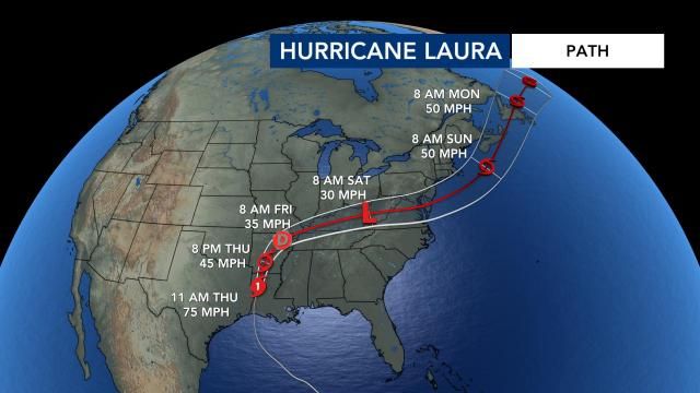
At 5:30 a.m., Laura was a Cat. 3 storm with 120 mph winds. At 6:45 a.m., Laura had weakened to a Cat. 2 storm with 110 mph winds. Flooding and wind damage will remain threats throughout the morning even as Laura weakens.
Beginning at 7:30 a.m. Thursday at the State Farmers Market in Raleigh, multiple farms, including Fords produce company, will start shipping food to the Gulf Coast area through Operation Barbecue Relief, an organization that responds to natural disasters to help feed displaced residents and emergency personnel.
The supplies will feed people in Louisiana over the next seven days.
Hurricane Laura a record-setting storm
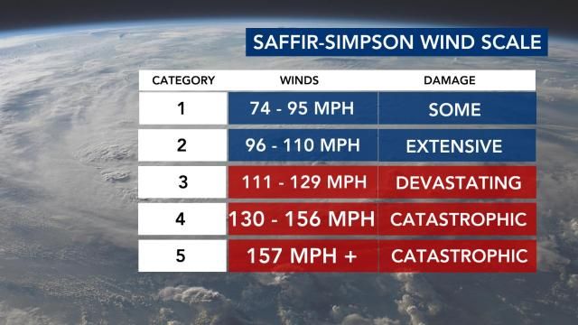
Hurricane Laura came dangerously close to becoming a Category 5 storm. A storm with winds of 157 mph or greater falls into that category, according to the National Weather Service.
According to WRAL meteorologist Zach Maloch, Hurricane Laura ties a hurricane from 1856 as the strongest hurricane to make landfall in Louisiana when looking at maximum sustained winds. Katrina had 125 mph winds at landfall.
Hurricane Laura is the 7th major (Category 3 or greater) hurricane to hit the state of Louisiana in August. Texas is the only other state to have more major hurricanes hit in August.
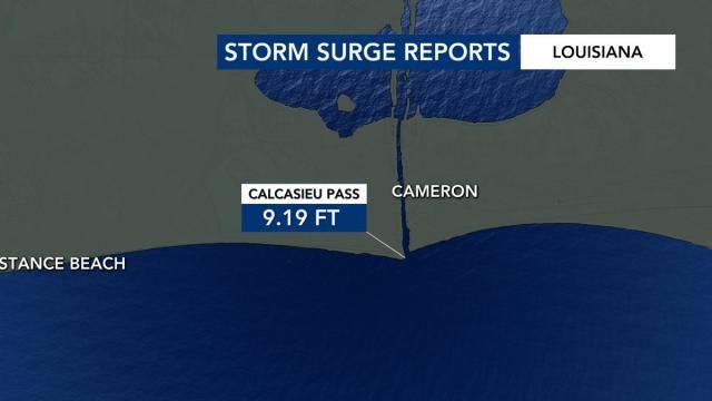
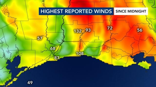
The highest winds reported were 138 mph in Lake Charles, Louisiana, and the highest storm surge reported was more than 9 feet near Cameron, where the storm made landfall. A 137 mph wind gust was reported at the emergency operations center in Lake Charles.
Hurricane Laura marks the 7th named storm to make landfall in the United States this hurricane season, breaking the old record of six named storms making landfall by the end of August.
The biggest impacts in Louisiana will be storm surge and strong winds. WRAL meteorologist Mike Maze said a storm surge of up to 14 feet and 40 miles inland is possible. The flooding it produces will be deadly in Louisiana and Texas.
The National Hurricane Center said "unsurvivable storm surge with large and destructive waves will cause catastrophic damage from Sea Rim State Park, Texas, to Intracoastal City, Louisiana, including Calcasieu and Sabine Lakes."
Between 4 to 8 inches of rain are likely, with 12 inches possible.
"In Louisiana, so much of that coast is at sea level – it's flat – so it's going to be devastating for them," Gardner said.
Gardner said the powerful storm is 400 miles wide from side-to-side and even wider from top to bottom. Hurricane force winds extend 70 miles from its center, but impacts will be even wider.
"We're going to see damage in a huge swath," Gardner said.
Since 1960, 25 Category 4 storms have been reported in the Gulf, but 10 of those occurred in the last 20 years, likely due to global warming, Gardner said.
While impacts from the large storm could stretch from Texas to Florida panhandle, Louisiana, the victim of Hurricane Katrina in 2005, will likely get the brunt of the storm, according to Gardner.
More than 385,000 residents were told to flee the Texas cities of Beaumont, Galveston and Port Arthur, and another 200,000 were ordered to leave low-lying Calcasieu Parish in southwestern Louisiana
The areas within the storm’s path that have issued mandatory evacuation orders include Port Arthur, Texas, which has the nation’s largest oil refinery, and Cameron Parish, Louisiana, just across the state line. Oil and gas companies have also evacuated workers from offshore production platforms in the Gulf of Mexico.
North Carolina could see some rain and wind late Saturday. The heaviest of the rain will be in the state's northern counties and into Virginia.