Things to know:
- For Friday's live coverage of Hurricane Dorian, click here.
- Hurricane Dorian is now a Category 1 storm, with sustained winds down to 90 mph. The eye is moving northeast just off the North Carolina coast at 14 mph.
- More than 208,000 customers are without power in North Carolina, according to the state's Department of Public Safety.
- Conditions were worsening in the Outer Banks, and tornadoes are most likely to strike north of the eye. See the full list of severe weather alerts.
11:38 p.m. Thursday — An update to the Jeep that was left stranded on the beach at Myrtle Beach, S.C. The owner of the vehicle was approached by police after the vehicle was stranded on the beach. The owner said he allowed one of his cousins to use it and he was the one who left it at the beach. In fact, the owner said he wasn't even aware what had happened to his vehicle. Watch the below video to learn more.
11:27 p.m. — Mandy Mitchell is in Jacksonville and said a curfew is in effect there, too. Police have pulled over some vehicles on the street and told them to go home instead of being on the roads. She is experiencing some of the strongest winds and rain as the storm continues its trek off the coast.
11:22 p.m. — Dorian continues to move up our coast and could miss landfall. However, the Outer Banks is still in the line of the storm.
11:03 p.m. — Dorian is still listed as a Category 2 storm with winds at 100 mph. It is located 35 miles off the coast of Wilmington and was moving at 13 mph. The latest projected path of the storm by the National Hurricane Center and WRAL has the storm just missing landfall at Cape Lookout. The storm earlier Thursday missed Cape Fear as it moved east.
10:38 p.m. — The death toll in the Bahamas from Huricane Dorian is now up to 30.
10:23 p.m. — WRAL meteorologist Mike Maze reports wind gusts are around 43 mph on the Outer Banks. Reporter Bryan Mims has been at the Outer Banks and said they are picking up consistent gusts of 20 mph or more. He said it was quite a contrast to Wednesday night, when there was little to no wind and it was muggy. Mims also said nobody is allowed in Dare County while Hurricane Dorian passes. Dare County Sheriff's deputies were posted at the US 64 bridge that takes you into the county. There is a curfew in place and people have been told to hunker down and stay safe until the storm passes.
10:04 p.m. — Flash flood warnings have been issued for Brunswick, Cumberland, Duplin, Harnett, Johnston County, Lenoir and New Hanover counties.
You can get more weather alerts here and tune to WRAL News now for the latest weather conditions from Dorian.
9:54 p.m. — Amanda Lamb is in Wilmington and said there have been some transformers that have blown in the Wrightsville Beach area, where evacuations were held Tuesday and Wednesday. She said the area was also experiencing bands of wind and rain was coming from all directions. Meteorologist Mike Maze said Johnnie Mercers Fishing Pier had wind gusts as high as 61 mph and the Wilmington airport was recording wind speeds at 54 mph.
9:27 p.m. — Duke Energy's website indicates there are now over 61,000 without power across eastern North Carolina. Jeff Brooks, a spokesperson with Duke Energy, said crews can't work to restore power once winds get above 39 mph. He said it's likely repairs will begin tomorrow. In the meantime, Brooks said to text "OUT" to 57801 to let them know you don't have power.
"Be patient and make sure you can provide for yourself for potentially a couple of days if you have an outage," Brooks said. "If you do see a downed power line, don't go near it, stay in your home, especially (Friday).
"You're going to be tempted to go out and see what's going on. We really advise you to stay home, stay cautious and let our crews do their work. We want to keep your family safe."
9:06 p.m. — A Pamlico County man died of a heart attack while trying to move his boat in preparation for Hurricane Dorian. He is the second person in the state to die because of the storm.
8:47 p.m. — Jason Sawyer, the man who shared the Ring doorbell camera video with WRAL News of his home being lifted off the ground during a tornado in Emerald Isle, shared more of his experience during our live coverage of Dorian.
8:30 p.m. — Kasey Cunningham reports the bridge to Atlantic Beach is closed and people trying to get in that area have been turned around by law enforcement. Winds were picking up and sheets of rain and wind are blowing in and out as Dorian inches closer to the coast.
7:47 p.m. — President Donald Trump sent out this tweet a few minutes ago to show support for North Carolina as Hurricane Dorian continues to bear down.
7:35 p.m. — Duke Energy reports over 5,000 are without power in Robeson County and 4,000 are without power in Brunswick County. Over 2,000 are without power in New Hanover County and Onslow County has nearly 3,000 without power. Here in Wake County, there are over 1,600 without power and over 1,500 without power in Johnston County.
7:09 p.m. — WRAL's Adam Owens is at the Outer Banks. He reports Emergency Management is advising those in Dare County to shelter in place until the storm passes. Conditions will deteriorate overnight and remain hazardous through Friday afternoon. Curfews for all areas of Dare County, except for the Town of Kitty Hawk, will begin at 8 p.m. until noon on Friday. This curfew may be extended based on conditions.
7:04 p.m. — Jason Sawyer sent this video from the Ring doorbell camera as the tornado hit his home at Emerald Isle. 'Our home was destroyed,' he said.
6:41 p.m. — While New Hanover County Manager Chris Coudriet and Wrightsville Beach Chief of Police Dan House don't anticipate a repeat of Hurricane Florence's flooding, Amanda Lamb reports they warned Thursday afternoon that the area still faces the possible negative effects of a storm surge.
6:19 p.m. — Monica Laliberte reports storm surge in Kure Beach could reach up to eight feet. High tide is Friday at 1:22 a.m., adding to the possibility of rising waters. Huge waves were crashing up on the beach as the winds have picked up. Officials said they were optimistic from lessons learned from Hurricane Florence that flooding wouldn't happen again. Equipment was replaced and drains were cleaned out in advance. At Carolina Beach, the main lake there was drained, too, to help prevent flooding. A beach nourishment process, which added sand to the coast, was also expected to help.
6:14 p.m. — Winds were getting stronger along our coast as Hurricane Dorian continues a move closer to the coast. WRAL meteorologists Mike Maze and Kat Campbell say it's likely that if the storm makes landfall, it would be at Cape Lookout early Friday morning.
6:09 p.m. — There are 17 major roads that are impassible in the state, according to the NCDOT. Crews are working around the clock to open the roads as soon as possible.
5:55 p.m. — WRAL meteorologist Kat Campbell gave us a look at what's to come overnight.
According to Campbell, Dorian is 85 miles southwest of Wilmington. Dorian is a very large storm, so its rain bands have a far reach.
"The rain won't stop anytime soon," Campbell said, adding that the worst of the winds and rains will come while North Carolina is sleeping.
At 9 p.m., wind gusts could be as fast as 26 mph in Raleigh and worse to our southeast. Winds will be howling the worst at 2 a.m., around 50 mph in Raleigh, while people are asleep. Winds at those speeds could take down trees and powerlines, Campbell said.
Campbell said the Friday morning commute also looks rough, and conditions will start to improve in the afternoon and evening.
5:41 p.m. — Kasey Cunningham is at Atlantic Beach where residents were concerned about the risk of tornadoes, especially after the one that touched down in nearby Emerald Isle.
5:35 p.m. — Over 3.5 inches of rain have fallen in Clinton, while over 1.5 inches fell in Fayetteville. Hurricane Dorian is still pounding Myrtle Beach, South Carolina, which is just over 30 miles away from the eye of the storm.
5:25 p.m. — The current track shows Dorian is most likely to make landfall along Cape Lookout late Thursday night or early Friday morning. WRAL meteorologist Mike Maze said North Carolina could experience hurricane force winds until 2 p.m. on Friday, with the worst of the storm battering the coast around 2 a.m.
5:15 p.m. — In Wilmington, conditions have worsened. Officials there said storms are expected to intensify through 10 p.m., and storm surge could damage beach communities. New Hanover County has already seen flooding in low-lying areas, but county officials said most residents have evacuated their homes as asked. Shelters in New Hanover County are almost at capacity.
4:55 p.m. — WRAL meteorologist Mike Maze said Hurricane Dorian has weakened slightly and now has maximum sustained winds of 105 mph. The storm is moving northeast at 10 mph, and the eastern movement is good news, he said, although the storm could still make landfall along North Carolina's coast.
Along North Carolina's coast, conditions are worse than they were this morning as the bands from Hurricane Dorian get closer to our state.
WRAL meteorologist Kat Campbell said Dorian is approaching Cape Lookout and should speed up between 2 a.m. and 2 p.m. Friday morning will be "messy," Campbell said, before the storm moves out to sea later in the day.
4:50 p.m. — Durham Public Schools will operate on a two-hour delay on Friday.
Users are posting photos and videos of what could be a tornado that moved through Wilson County around 4 p.m. Multiple people posted that a tornado was seen on U.S. Highway 264.
4:05 p.m. — In a press conference, Gov. Cooper said 68 shelters are currently open in North Carolina, and those are holding more than 2,200 occupants. More shelters will open as the need arises. In Cumberland County, 70 people had checked in to the area's two shelters.
The N.C. Operations Center warned of flash flooding east of Interstate-95 and storm surge along the coast. Water rescue teams, ambulances and aircrafts are ready to assist people if the need arises, officials said.
The worst impacts of Dorian are yet to come for North Carolina, WRAL meteorologists and state officials said. Some roads are expected to become flooded and impassable overnight. The darkness will make it harder for travelers to see, and people were urged to stay off the roads as conditions worsen.
"We'd rather have people stay home and hunker down," Cooper said. "We have a long night ahead of us."
The Department of Transportation said at least 17 major roads were closed in the state, including U.S. Highway 117 in New Hanover County and U.S. Highway 17 in Brunswick County.
4:00 p.m. — A tornado warning was issued for Wilson County until 4:45 p.m.
3:55 p.m. — The National Weather Service has issued a tornado warning for Cumberland County that lasts until 4:15 p.m.
3:35 p.m. — Wake County Public Schools has canceled classes Friday as Hurricane Dorian brings tornadoes and heavy rain to North Carolina.
3:22 p.m. — Calypso Cottage in Beaufort shared a video on Facebook showing wild horses moving through floodwaters to higher ground. Experts say
wild horses are better equipped to handle a hurricane than most humans living on the Outer Banks and will go under sturdy live oak trees to ride storm outs.
2:46 p.m. — A possible tornado was reported in Mar-Mac in Wayne County.
The National Weather Service said a barn was destroyed and a roof was damaged as Hurricane Dorian started heavily impacting North Carolina on Thursday.
A vehicle was also moved, the National Weather Service said.
2:42 p.m. — A flash flood warning was issued for Wayne County.
Drivers should never try to go through floodwaters. One foot of water can float many vehicles, while two feet of rushing water can carry away SUVs and pick-ups. Dirty water can make depths hard to determine.
2:30 p.m. — North Carolina has had about 15 tornado warnings as Hurricane Dorian's bands move on land, WRAL meteorologist Elizabeth Gardner said.
"Typically they come and go pretty quickly," she said. "The farther you get from the center of the storm, the less energy there is to sustain a tornado."
As the center of the storm approaches Wilmington, that energy to sustain tornadoes moves inland.
Heavy rain has started in the Triangle area, and a flood advisory is in effect for southern Wake County, parts of Cumberland and Sampson counties and most of Harnett and Wayne counties until 5:15 p.m.
2:08 p.m. — More than 3,200 power outages have been reported across North Carolina. Nearly 600 are in Pender County.
2 p.m. — Hurricane Dorian's eye is just offshore of Cape Romain, South Carolina, the National Hurricane Center said.
The center is 115 miles away from Wilmington. The storm continues to move northeast at 8 mph with sustained winds reaching 110 mph.
1:54 p.m. — A tornado warning has been issued for southeastern Johnston County and west central Wayne County that stretches until 2:30 p.m.
1:20 p.m. — All American Airlines flights out of Fayetteville Airport were canceled. Thrifty and Dollar car rental services were closed until Friday.
12:50 p.m. — Some rotation was seen in Wayne County, and tornadoes are possible throughout eastern parts of the state.
Between 3 and 5 inches of rain have fallen in the past six hours, mostly southern North Carolina.
The eye of Hurricane Dorian is 112 miles away from Wilmington and could make landfall on the N.C. coast.
“It’s going to need a good kick to move on out,” WRAL meteorologist Elizabeth Gardner said. “The cold front is trying. It’s trying to push, and we’re looking at that push starting to take place, but of course we’re still looking at very strong winds.
“No matter what happens, we’re going to see hurricane-force winds all along our coast,” she said.
12:40 p.m. — A Jeep SUV was surrounded by waves in Myrtle Beach as people watched and took pictures with the flooded vehicle.
12:30 p.m. — The Coast Guard has aircraft and two shallow-water rescue boat teams in North Carolina waiting for safe conditions to begin search-and-rescue operations.
The Coast Guard urged people to stay off the water as rescue efforts may be delayed during the height of Hurricane Dorian.
12:28 p.m. — A tornado warning is in effect for Bladen County until 1 p.m. and for Duplin and Lenoir counties until 1:15 p.m.
12:25 p.m — The National Hurricane Center has released revised information, and Dorian remains a Category 2 storm. The center of circulation is 30 miles away from Charleston, South Carolina.
12:09 p.m. — Hurricane Dorian has been upgraded again to a Category 3 storm as it makes its way toward North Carolina.
11:45 a.m. — The eye of Hurricane Dorian is 135 miles away from Wilmington and was very close to Charleston, South Carolina.
The eye could make landfall over Wilmington, but dangerous conditions are likely regardless.
“It may not make a lot of difference unless it were to come way inland, which doesn’t look likely,” WRAL meteorologist Elizabeth Gardner said.
A tornado warning was in effect for Pender and New Hanover counties.
Numerous waterspouts were seen along the North Carolina beaches, and tornadoes were reported on land, too.
“Some of these waterspouts, what they’re doing is they’re getting all the way on the land, and once it’s on land it’s a tornado,” WRAL meteorologist Aimee Wilmoth said.
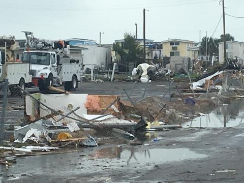
11:32 a.m. — What was believed to be a water spout or tornado has left a wide swath of damage on Emerald Isle.
Reporter Sloane Heffernan and photojournalist Greg Clark found devastation in the town. There are piles of debris; one mobile home has been flipped on its side; a resident whose home was damaged during Hurricane Florence also suffered some damage this morning. The damage was done from a storm that spun up from the hurricane's outer bands.
11 a.m. — Hurricane Dorian's maximum sustained winds fell to 110 from 115 mph, the National Hurricane Center said in its 11 a.m. forecast, making the storm a Category 2.
Its eye was 140 miles away from Wilmington, where it could easily make landfall, WRAL meteorologist Elizabeth Gardner said.
Dorian was moving northeast at 8 mph.
10:40 a.m. — A family in Pender County shared video with WRAL News of an apparent tornado whipping trees and roofs Thursday morning.
The family has lived near Highway 17 for generations, and they immediately took cover when they saw the swirling gusts.
“They honestly had seconds to react to this,” WRAL’s Nia Harden said.
No one was injured.
The tornado appeared to zig-zag across people's backyards without destroying houses.
10:31 a.m. — A curfew will go into effect at 8 p.m. Thursday until 12 p.m. Friday in all areas of Dare County except for Kitty Hawk. There will be no access into Dare County starting at 8 p.m. Thursday.
10:30 a.m. — A curfew in Carteret County will be in effect from dusk on Thursday to dawn on Friday.
10:28 a.m. — The Town of Emerald Isle posted on Facebook that a water spout or tornado touched down at Islander and Reed drives around 9 a.m.
10:25 a.m. — Wayne County curfew to be in effect from 9 p.m. Thursday until 6 a.m. Friday.
10:05 a.m. — Gov. Roy Cooper urged people in North Carolina to seek safety as Hurricane Dorian begins to impact North Carolina.
"Hurricane Dorian is ready to unleash its fury on our state," he said at a news conference. "It is serious, and it can be deadly."
"Get to safety and stay there," he continued. "Don’t let your guard down."
Cooper warned of tornadoes, flash floods and intense winds.
He asked people to see shelter and to stay off the roads to keep themselves and rescuers safe.
9:30 a.m. — At least two trees were uprooted and a building was damage when an apparent tornado moved through Pender County, WRAL's Nia Harden reports.
A woman said she had to evacuate Topsail and was staying in a building in Pender County on Highway 17.
When she and her family members heard what sounded like a tornado, they huddled together in the middle of the building until it passed.
Insulation from the building was scattered on the ground afterward.
Earlier Thursday, the National Weather Service in Wilmington tweeted a video of the tornado.
8:50 a.m. — Bands of rain were moving into Fayetteville, Clinton and Johnston County as the eye of Hurricane Dorian was 45 miles off the coast of Charleston, South Carolina.
While the storm remains a Category 3 storm, it is expected to hit Wilmington as a Category 2.
One particular band of rain has produced numerous tornadoes as it has moved through the Wilmington area and northward, WRAL meteorologist Elizabeth Gardner said.
This media cannot be viewed right now.
8 a.m. — Hurricane Dorian remains a Category 3 storm as it approaches the North Carolina coast at 8 mph, the National Hurricane Center said in its 8 a.m. forecast.
The eye of the storm was 170 miles away from Wilmington, but several areas of the state are under hurricane, tropical storm and tornado alerts.
Dorian's maximum sustained winds were 115 mph. Hurricane-force winds extended 60 miles from the eye.
The eye is expected to move near or over the North Carolina coast Thursday night and into Friday.
Two shelters opened at 8 a.m. in Cumberland County, including the Smith Recreation Center in Fayetteville and South View High School in Hope Mills.
Several businesses in Fayetteville have prepared for the storm with sandbags, and several hotels in Fayetteville were at capacity.
7:32 a.m. — The effects of Hurricane Dorian was already felt in Wrightsville Beach as people reported power outages and flooding.
Many people had heeded warnings to evacuate before Dorian hit the coast.
One man left his home to head to Raleigh because he plans to attend a wedding in Pennsylvania over the weekend.
“It’s been like a ghost town here,” WRAL reporter Nia Harden said.
A Food Lion had many customers, but employees said the store would close around 11 a.m. or noon.
7:30 a.m. — The Brunswick County Sheriff's Office posted multiple pictures of damage on its Facebook page, including debris on Dorothy Trail and Highway 17.
Ethan Clark, a meteorology intern at WRAL, shared a video of a water spout near the east end of Ocean Isle.
A tornado watch was issued for Cumberland, Duplin, Edgecombe, Johnston, Lenoir, Nash, Sampson, Wayne and Wilson counties until 7:00 p.m.
At Emerald Isle, waves were crashing and sand was blowing Thursday morning.
"I am feeling a little nervous,” a man walking on the beach said. “I think a lot of people aren't prepared.”
6:25 a.m. — Utility crews from across the country are staging in Raleigh so they can move in to start restoring power as soon as Hurricane Dorian leaves.
Hundreds of trucks were at Coastal Credit Union Music Park, ready to deploy to areas that lose power.
The utility company nearly doubled its fleet of linemen, adding 4,000 crew members from 23 states to handle issues from the storm.
Widespread outages are expected from the coast even to the Triangle.
6:20 a.m. — Conditions were calm in Dare County, with low surf and light winds, but “we shouldn’t be fooled by any of this,” WRAL reporter Adam Owens said.
Storm surge could be as high as 6 feet as the eye of Hurricane Dorian is expected to move near or over the North Carolina coast Thursday evening and into Friday.
Emergency officials say people need supplies to sustain themselves for 72 hours.
John Silver’s home has been standing since 1875, and it’s weathered many storms.
“We’ve always just pieced it back together,” Silver said. “Originally we would find driftwood on the beach and — my ancestors would, and then we would — piece it back together.”
The house has been moved back away from the sea as the years have gone on.
Silver said he thinks his house will fare well in Dorian, but emergency officials said people shouldn’t stick around to see.
5:03 a.m. — At Pine Knoll Shores near Atlantic Beach, some locals decided to wait out the storm despite mandatory evacuation orders.
"I lost my house to Florence, so I have been homeless for a year, and now here we go again," a local woman told WRAL News at the Tackle Box Tavern.
Winds were picking up at Pine Knoll Shores early Thursday morning, and the area could get up to a foot of rain.
5 a.m. — Dorian is a Category 3 hurricane with sustained winds reaching 115 mph, the National Hurricane Center said Thursday morning. The storm's center is expected to move near or over the North Carolina coast Thursday evening and overnight into Friday.
A tornado warning was issued for southeastern Brunswick County until 5:15 a.m. as the hurricane's eye was 200 miles away from Wilmington. It was moving north at 8 mph.
The National Hurricane Center's 5 a.m. forecast showed Dorian moving up the South Carolina and North Carolina coasts and turning northeast sometime Thursday.
“It’s certainly continuing to look like the storm is going to ride right up the coast of North Carolina, and if it bobbles inland, it shouldn’t be very much,” WRAL meteorologist Gardner said.
“Even if the storm stays well offshore, this is still going to be a very big deal for the coast of North Carolina,” she added.
A hurricane warning is in effect for the entire North Carolina coast, with sustained winds at 55 to 85 mph and gusts up to 110 mph.
The southern North Carolina coast could see 4 to 7 feet of storm surge. The central coast could see 4 to 6 feet of storm surge, and 2 to 4 feet of storm surge is expected along the northern coast.
East of Goldsboro, 6 to 12 inches of rainfall is expected.
A tropical storm warning is in effect from Raleigh to Greenville, with 30-40 mph winds and gusts between 40 and 60 mph expected.
The Triangle could see 1 to 3 inches of rain, and Fayetteville could see 4 to 6 inches of rain. Goldsboro could see 4 to 8 inches of rain.