Are you dreaming of a 'White Christmas'? Let's break down our chances
Are you dreaming of a white Christmas? The odds may be slightly higher than the historical probability (just 2%) but Saturday afternoon's trends aren't favorable for snow lovers.
Posted — UpdatedAre you dreaming of a white Christmas? The odds may be slightly higher than the historical probability (just 2%) but Saturday afternoon’s trends aren’t favorable for snow lovers.
Cold air is coming. That’s for sure! We are very confident in our forecast that freezing cold air from Siberia will arrive in NC next weekend for Christmas. We expect highs to only reach the 30s on Christmas Eve and Christmas.
The big question isn’t will it be cold enough, but when will it be cold and will it be in time to line up with the moisture. The timing of the moisture is starting to come together on the models in the Wednesday night through early Friday time frame.
This means we’re about 5-7 days away from any potential precipitation. Our WRAL snow forecast timeline puts us in the “monitor trends” phase of potential winter weather forecasting. Saturday’s trends show a decreasing chance for winter weather late in the week.
The European model has been more consistent over the past few days in keeping central NC mostly snow free through Christmas. With a less amplified jet stream unable to position the low pressure and moisture in the “sweet spot” for NC snow, the European model limits accumulating snowfall to the NC mountains.
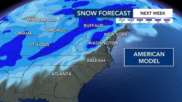
What’s new Saturday afternoon is the American model, which previously showed a better positioned low pressure system and more favorable timing for snow, has backed off snow chances in a few consecutive runs. The new model data is more in line with the European and other global models showing a less amplified jet stream and more rain in central NC.
While the odds for accumulating snow are trending lower, models are still showing the potential for a few brief flurries mixing in on the back side of this system on Friday. Typically cold air chasing moisture doesn’t produce much, but a few flurries leading up to the holidays may be enough to make a snow lover smile!
All hope isn’t lost yet. There’s still time for trends to change so we encourage you to keep checking back in for updates next week. Regardless of whether it’s rain or snow, this system will still impact travel in NC and much of the country.
Last White Christmas in NC
So, while the odds are not in our favor, snow lovers keep hoping as it only takes one unique weather setup for us to be dealing with a wintry wonderland. Happy holidays!
• Credits
Copyright 2024 by Capitol Broadcasting Company. All rights reserved. This material may not be published, broadcast, rewritten or redistributed.


