Irene leaves NC, drenches mid-Atlantic coast
After lashing the North Carolina coast with wind, sand, rain and sea for more than 12 hours, Hurricane Irene's center of circulation trudged out of the Outer Banks Saturday evening, heading northeast along the Atlantic Coast. But the hurricane's effects are still being felt in parts of the Outer Banks.
Posted — UpdatedBut the hurricane's effects were still being felt in parts of Dare County, where high tide brought severe flooding to Kitty Hawk, Roanoke Island, Mann's Harbor and Manteo. Many areas are inaccessible and the dark is making it difficult for rescue crews to get to the people affected, said Kathryn Bryan, spokeswoman for Dare County Emergency Management.
A Nash County man was also killed after he was hit by a falling tree.
Irene's powerful wind gusts blew off part of the roof at Tarboro High School, destroying two classrooms and damaging several others, the school's assistant football coach told WRAL News.
At Bath Elementary near Belhaven in Beaufort County, wind peeled the fabric roof off the gymnasium, allowing rain water to gush inside. More than two feet of standing water also flooded the parking lot at the school. There were no reports of injuries.

A small part of the roof collapsed inside the Belk’s store at Berkley Mall, at Berkley Boulevard and U.S. Highway 70, in Goldsboro and some businesses have flooding damage, City Manager Scott Stevens said.
The storm came ashore near Cape Lookout at 7:47 a.m. with maximum sustained winds at 85 mph, WRAL Chief Meterologist Greg Fishel said. The coast saw steady winds between 75 and 90 mph, while the National Hurricane Center recorded a gust of 115 mph at the Cedar Island ferry terminal. Winds gusted up to 64 mph as far inland as Wayne County.
Many roads were impassable Saturday night as high tide caused severe flooding, particularly on the sound side of the Outer Banks. N.C. Highway 12 in Duck was completely under water as of 9:30 p.m.
The Nags Head-Manteo Causeway, sections of South Croatan Highway and most of West Kitty Hawk Road were also impassable.
Curfews are in place throughout the area, and officials are asking people to stay off the roads.
Dare County Emergency Management expects the flooding to worsen throughout the night and were sending crews door to door to try to move residents to safer areas.
Hurricane force winds knocked down a gas pump and damaged the Ramada Inn in Kill Devil Hills, and ripped parts of the Nags Head Food Lion’s storefront off the building. But perhaps the most unexpected damage associated with the storm were fires, sparked by downed power lines and exploding transformers throughout Dare County.
Nobody was injured and crews were able to extinguish the fires quickly.
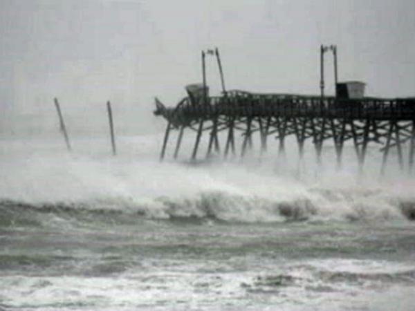
The rain has stopped at Atlantic Beach after several relentless hours that caused severe flooding and battered the iconic Sheraton Hotel fishing pier, sending the last 30 yards of it crashing into the violent surf Saturday afternoon.
The entire barrier island on the Crystal Coast lost power as the storm surge kicked up and surrounded many homes with water. Several roofs were damaged, but officials have not received any reports of significant structural damage to any buildings.
More than 16 inches of rain fell in Beaufort County as of 5 p.m. and 30 to 40 mph wind gusts began battering businesses in downtown Washington just after sunrise. The gale ripped awnings off buildings, shattered windows and tossed debris around Main Street.
Glenn Williams watched the storm from his downtown office.
"I just come down here in the hurricane because it's safer than it is at home where all the trees are at," he said.
In Nash County, the Tar River surged well above flood stage in Rocky Mount, where there was also been flash flooding throughout the day. City officials declared a state of emergency and urged people to stay at home.
The North Carolina Urban Search Rescue Task Force 9 was sent to New Bern, which has been hard hit by flooding. A 7-foot storm surge sent high waves and water rushing up the Neuse River, prompting numerous calls from people who asked to be rescued, an emergency management spokeswoman said. Crews made swift-water rescues, including at least one family with small children.
Significant flooding has also been reported in Hyde County, along the Pamlico Sound. Waters have topped a dike protecting the town of Swan Quarter.
Irene created a storm surge of 6 to 10 feet as it moved north up the North Carolina coast, and communities on the western side of the Pamlico Sound were particularly at risk as the storm pushed water in that direction. Water on the roadways made several highways impassable, making it possible for WRAL News crews to access the sound side of the Outer Banks, where many viewers are reporting significant flooding.
Ten major roads have been closed, including U.S. Highway 64 West in Columbia, U.S. Highway 264 in Belhaven, N.C. Highway 12 near Rodanthe and Salvo in the Cape Hatteras National Seashore, and U.S. Highway 301 between Halifax and Weldon.
Evacuation orders were issued in 18 counties, and up to 8,000 people sought refuge in American Red Cross shelters in 16 counties.
Nearly a million people lost power along the coast and as far inland as Wake, Durham and Orange counties at the height of Saturday's storm. Hurricane force winds slowed utility crews' ability to restore power quickly, but more than half of those affected had power by midnight.
Officials said it could take up to three days to restore power in remote areas.
Lee Sartain, who lives off New Bern Avenue near WakeMed Hospital in Raleigh, said his power service was intermittent before going out completely for about six hours. It was restored around 7 p.m.
"It wasn't too big of a deal. I grabbed the radio and it wasn't too hot, so we were able to ride it out with no problem," he said.
He said his neighborhood seems prone to outages.
"During any major storm, we do tend to lose power for a little bit. We have a lot of large, mature trees and any limb will take out a line," Sartain said. "We last lost it in the April tornadoes, but luckily because we're near the hospital, we're back online pretty quickly."
Nash General Hospital in Rocky Mount and a hospital in Morehead City had lost power and were using emergency generators. The emergency centers in Dare and New Hanover counties were also operating off generators.
Tens of thousands of people lost power along the North Carolina coast. In Pamlico County, 98 percent of Progress Energy customers were without electric service at the height of the outage.
At 8 p.m., Progress Energy reported power outages affecting 206,000 customers: 24,000 in Carteret County; 23,000 in New Hanover County; 22,000 in Wayne County; and at least 10,000 each in Wake, Onslow, Johnston, Craven, Nash and Lenoir counties. At the peak of the storm, around 2 p.m., nearly 280,000 of the utility's customers were without power.
Duke Energy had 22,000 customers without service at the peak of their outage, around 2:45 p.m. They hoped to have power restored to everyone by midnight.
A new inlet might have been carved through Hatteras Island, between Hatteras and Frisco, said Warren Judge, chair of Dare County Shoreline Management Commission. He said some people say it's a breach, while others say it's just overwash from the ocean. Crews haven't been able to get close enough to check it out.
High tide and tall waves combined to tear at beaches and waterfront structures Saturday morning.
The end of the Bogue Inlet pier collapsed, Emerald Isle town manager Frank Rush said.
Two wastewater treatment plants in New Hanover County and Tyrrell counties have been breached, but the cause and severity of the breaches weren't clear.
Three possible tornadoes were reported in Carolina Beach, Beaufort County and Tyrrell County late Friday night and early Saturday morning.
Injuries were reported in Columbia, where a possible tornado damaged buildings along the 1400 block of U.S. Highway 64.
A Belhaven town officials said witnesses believe a tornado pushed a mobile home off its foundations and obliterated Edgewater Motors around 11 p.m. Friday. The suspected tornado also punched a hole in the roof of another home.
Employee Willie Midgette said he was at the car dealership and heard a sound like a train, so he headed to an interior bathroom. He escaped unharmed.
An emergency management official said a funnel was spotted on Carolina Beach. No injuries were reported.
Tornado watches have been lifted from eastern and coastal counties.


• Credits
Copyright 2024 by WRAL.com and the Associated Press. All rights reserved. This material may not be published, broadcast, rewritten or redistributed.


