Hurricane Michael on track to bring wet, windy end to the week
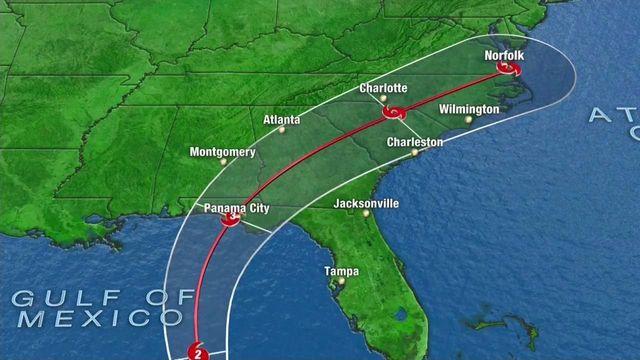
The National Hurricane Center has upgraded Michael to a hurricane and it is expected to make landfall later this week as a Category 3 storm somewhere along the Florida Panhandle.
Posted — Updated- Hurricane Michael has top winds of 90 mph and it could be a Category 3 storm with 120 mph winds when it makes landfall Wednesday in the Florida Panhandle
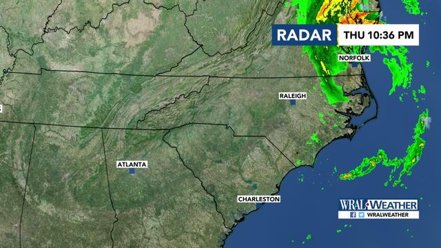
- North Carolina and the Triangle could see 3 or more inches of rain, starting Wednesday and lasting into Friday.
- Wind gusts in central North Carolina could reach 40-60 mph.
- The greatest threat in North Carolina is for flash flooding in low-lying areas already saturated by the days of rain last month from Hurricane Florence.
The National Hurricane Center on Monday upgraded Michael to a hurricane as Floridians readied their storm kits and evacuation plans for the possibility of landfall as a Category 3 storm.
At 11 p.m. on Monday, Hurricane Michael was more than 900 miles south-southwest of Raleigh with maximum sustained winds of 90 mph and moving north at 12 mph. The storm is expected to make landfall sometime on Wednesday in the Florida Panhandle before moving up into Georgia and the Carolinas, dropping up to 3 inches of rain in parts of the Triangle late Wednesday into Thursday.
WRAL meteorologist Mike Maze said that Michael could bring winds between 40 and 60 mph, the threat of flash flooding, isolated tornadoes and scattered power outages to the state.
"Most of the effects would be low to moderate but, when you look at the flooding, we could be looking at a high threat, especially in the locations that saw the severe flooding from Florence," he said.
Maze said the cone of uncertainty covers a large portion of the state, so it's too early to tell who will see the worst impact from the system.
"Anybody here in central North Carolina could really get nailed by this storm," he said.
Gardner said once Michael has moved through the region, it will be dry and brisk, bringing a taste of true fall weather to central North Carolina.
Florida on alert
Florida Gov. Rick Scott says Hurricane Michael is a "monstrous storm" that has the potential to be devastating to the Florida Panhandle.
Speaking alongside emergency officials in Pasco County, Scott said Monday he's waiving tolls. He also has declared a state of emergency for 35 counties and asked President Donald Trump for assistance ahead of the storm.
The governor warns that storm surge could be as high as 8-10 feet (2.4-3 meters) in some parts of the Panhandle and 2-4 feet (0.6-1.2 meters) in the Tampa Bay area. Scott is urging people along the Gulf Coast to finish their storm preparations Monday evening.
Residents of barrier islands, mobile homes and low-lying coastal areas in Gulf, Wakulla and Bay counties were ordered to evacuate by late Monday or early Tuesday.
Michael lashing Caribbean islands
Hurricane Michael is lashing the western tip of Cuba with heavy rainfall and strong winds.
The National Hurricane Center in Miami says Michael's top sustained winds were around 75 mph (120 kph). The storm was moving north around 7 mph (11 kph).
The storm was centered about 20 miles (30 kilometers) off the western tip of Cuba, and about 145 miles (230 kilometers) east-northeast of Cozumel, Mexico.
Forecasters say Michael will move into very warm waters in the Gulf of Mexico. It could strengthen into a major hurricane with winds topping 111 mph (178 kph) before an expected strike Wednesday on Florida's Panhandle.
Meanwhile, long-lived Tropical Storm Leslie was expected to gradually strengthen over the Atlantic Ocean but was no threat to the U.S. coastline.
• Credits
Copyright 2024 by WRAL.com and the Associated Press. All rights reserved. This material may not be published, broadcast, rewritten or redistributed.


