Flash flooding likely as Alberto brings heavy afternoon rain
Subtropical storm Alberto is bypassing North Carolina entirely, but central and western portions will feel its indirect effects Monday in the form of heavy rains and possible flooding.
Posted — UpdatedAlberto was expected to make landfall sometime Monday evening along the Florida Panhandle.
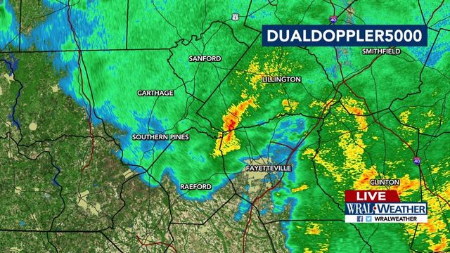
"Today we will likely have some tropical moisture pushed our way from a system in the Gulf of Mexico," said WRAL meteorologist Elizabeth Gardner. "That brings us cloudy skies and a good chance for showers and a few thunderstorms, with some locally heavy downpours and localized flash flooding possible."
Much of central North Carolina will be under a flash flood watch effective Monday at 1 a.m. and lasting into Tuesday as subtropical storm Alberto passes to the west.
"This rain is going to start to pick up in intensity for our southern counties, but it could be this afternoon before it gets heavy around the Triangle," said Gardner. "There's not going to be a lot of grilling or boating going on -- it's going to be messy."
On Monday, Alberto was off the coast of Florida, moving north towards Tennessee. As a result, western North Carolina will see the heaviest rains. The storm is also pushing rain bands towards the coast, Gardner said, so there could be some heavy rain there as well. Alberto's center is expected to make landfall around mid-afternoon Monday near Pensacola, Florida.
With all the rain around, Monday's high temperature will only get to about 76 degrees. Central portions of the state could see anywhere from 1 to 3 inches of rain.
According to Gardner, the rain will come in bands Monday, picking up in intensity with some heavy downpours before slowing down. "We're going to see that pretty much all day," she said.
By Tuesday, showers will be more scattered, and it warms back into the 80s.
"Most of the rain will be today and tonight," said Gardner, although scattered storms and showers will be present throughout the week.
Flash flood watch issued for central North Carolina
Wake County is under the watch from 1 a.m. on Monday through 8 a.m. on Tuesday along with Chatham, Cumberland, Edgecombe, Franklin, Harnett, Hoke, Johnston, Lee, Moore, Nash, Sampson, Scotland, Wayne and Wilson counties.
Gov. Roy Cooper issued a statement calling on North Carolina residents from the mountains to the coast to watch the weather and be prepared.
"With the ground already saturated in many parts of the state, we are urging people to be prepared for possible flash flooding, hazardous road conditions and river flooding," he said.
State Emergency Management meteorologists predict rainfall totals possibly reaching 8 inches along the eastern and southern slopes of the western North Carolina mountains over the next few days.
Gulf Coast already feeling Alberto's effects
Subtropical Storm Alberto - the first named storm of the 2018 hurricane season that starts June 1 - prompted Florida, Alabama and Mississippi to launch emergency preparations Saturday. Rough conditions were expected to roil the seas off the eastern and northern Gulf Coast region through Tuesday.
"These swells are likely to cause life-threatening surf and rip current conditions," the National Hurricane Center in Miami said in a statement.
The hurricane center said Sunday that a tropical storm warning was in effect from Bonita Beach, Florida, to the Mississippi-Alabama border.
With conditions expected to worsen overnight officials are encouraging vacationers leaving the Gulf Coast on Monday to give themselves extra time.
Jeffrey Medlin, meteorologist in charge at the National Weather Service's Mobile office, warned that even after the storm moves north there will still be swells coming up from the south that could cause dangerous rip currents.
Isolated tornadoes were possible across the region on Sunday and Monday.
A subtropical storm like Alberto has a less defined and cooler center than a tropical storm, and its strongest winds are found farther from its center. Subtropical storms can develop into tropical storms, which in turn can strengthen into hurricanes.That tropical moisture will make its way into North Carolina Monday and Tuesday.
Related Topics
• Credits
Copyright 2024 by WRAL.com and the Associated Press. All rights reserved. This material may not be published, broadcast, rewritten or redistributed.


