To the trained eye, one of North Carolina's most dangerous natural hazards is often visible from the shore.
It appears as a gap in the crashing waves, a narrow passage where a rush of murky water flows straight out to the ocean. Rip currents form and dissipate suddenly, the product of a complex blend of factors like wave energy and the shape of the sandy bottom.
Other WRAL Top Stories
And since 2000, they've claimed more than 100 lives in the Carolinas, an average of seven a year.
North Carolina beaches have already seen seven rip current drownings in 2019, with summer not even halfway over. A WRAL News analysis of National Weather Service data, meanwhile, shows that the state's southeastern beaches have seen an uptick in higher-risk rip current forecasts over the past 10 years.
With more and more people flocking to the state's coast every year, meteorologists say improving rip current predictions can save lives. To do that, they're turning to new technology to get a better handle on a deadly phenomenon that can be notoriously difficult to forecast.
"There's a lot of subjectivity involved in this game, which makes our lives pretty challenging," Mark Willis, meteorologist in charge at the National Weather Service's Wilmington office, said. "Rip currents are hard."
{{social}}
For the last decade, Greg Dusek has been trying to find ways to overcome one of the biggest issues with forecasting rip current: The sheer lack of data.
Meteorological observations are used to model things like rain, severe weather and even tornado activity. But it's difficult for scientists to get ocean observations in the surf zone, where instruments are battered by rough surf and shifting sand.
"If you can't observe the phenomena you're trying to forecast, it's really hard to nail down what should go into a forecast model," said Dusek, a senior scientist with NOAA's National Ocean Service.
Until recently, the National Weather Service's wave modeling stopped miles short of the shore. And it's still difficult to measure big rip current factors like bottom depth along the coast's rapidly changing shoreline.
But the forecasts can give beachgoers an idea of the potential risk before they head to the water.
WRAL analyzed 10 years of NWS forecasts issued for southeastern North Carolina beaches along Brunswick, New Hanover and Pender counties. That includes popular locations like Bald Head Island, Wrightsville Beach and Topsail.
Month to month, the percentage of forecasts noting either moderate- or high-risk forecasts increased slightly, particularly in 2017 and 2018. The data shows those riskier forecasts are about 11 percent more frequent now than in 2008.
Anecdotally at least, Dusek said WRAL's findings seem to track other upticks in drownings and rescues along the coast.
Last year, for example, between Memorial Day and Labor Day, lifeguards at Wrightsville Beach rescued 475 people. About 350 of those rescues were swimmers caught in rip currents, according to data from the United States Lifesaving Association.
More swimmers were rescued from rip currents at Wrightsville Beach during the summer of 2018 than any other summer since the group began collecting data in 2003.
But observations on the ground, Dusek said, are complicated by the bigger and bigger crowds the state's beaches are seeing year after year.
According to Visit North Carolina, tourism spending in the state's southern coastal counties of Pender, New Hanover and Brunswick, was up 19 percent between 2013 and 2017.
"Drownings are not necessarily indicators of risk, because they're dependent on people," Dusek said.
Even the forecasts themselves, Dusek said, have been refined over time with better data and slightly improved techniques.
"You probably can't say with much confidence that just because there are more high forecasts, there are stronger risks," he said.
{{social}}
As they currently stand, one of the major limitations of the current rip current predictions is a lack of specificity – each forecast area covers a miles-long stretch of coastline.
But that's due to change by next beach season when the National Weather Service rolls out a new approach that's been in the works for years.
"You get much more information," Dusek said. "Instead of having a daily forecast issued for 20 miles of beach, you get an hourly forecast every kilometer up to six days in the future."
The new forecasts will still have plenty of limitations, though. And Dusek's current research is focused on using other techniques – a mix of old and new – to account for other factors like the shape of the ocean floor.
Since the late 1980s, researchers have used high-quality cameras to monitor the ocean from the shore. By combining images into composites, they can glean more information about wave activity and the rip currents that appear where the waves don't break. But these cameras were typically limited to field research facilities and needed a lot of manual analysis.
But Dusek is working to combine machine learning with the numerous beach webcams now dotting the coast, using the same basic technique to add more information to existing rip current modeling.
Those coming breakthroughs, he hopes, will help meteorologists equip the public with even better information in forecasts they already have access to.
"People want to know, because they know it's a risk," Dusek said. "Providing it in a way so it can be useful to people, that whole prevention part is a big component too."
NOAA and the National Weather Service have pushed hard to raise rip current awareness over the past two decades, and alongside improvements to their modeling have also sought to better understand the social science behind how people react to potential drownings.
That's one of the reasons they've closely tracked drowning deaths due to rip currents in the Carolinas, which have tallied 138 since 2000.
Those totals, according to agency meteorologist Steve Pfaff, make rip currents the number-one weather-related killer here.
North and South Carolina residents account for more than half of the drownings, and the vast majority of victims are men aged 31 to 50.
NWS started tracking more detailed data about rip current drownings in 2011, Pfaff said. Their analysis shows 26 percent of those deaths were bystanders and Good Samaritans who attempted to make rescues.
Pfaff said that statistic highlights the importance of flotation devices for anyone trying to make a rescue on the beach.
"Lifeguards call these things drowning machines for a reason," Pfaff said. "They're very efficient."
{{social}}
Rip current survival tips
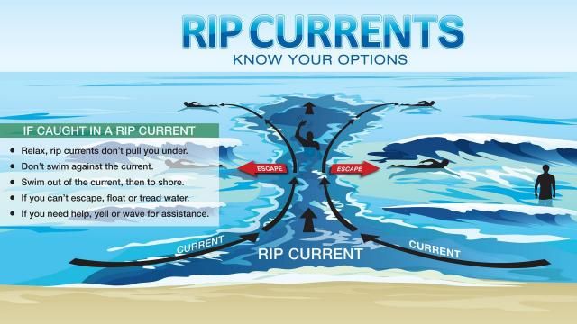
- If caught in a rip current, remain calm to conserve energy. It will not pull you underwater, but it will pull you away from shore.
- Don’t fight the current. Swim out of the current by swimming parallel to the shoreline. When out of the current, swim towards shore.
- If you are unable to swim out of the rip current, float or calmly tread water. When out of the current, swim towards shore.
- If you are still unable to reach shore, draw attention to yourself. Face the shore, wave your arms and yell for help.
- Always let a lifeguard with a flotation device make a rip current rescue.