4 reasons Hurricane Michael was so devastating
Hurricane Michael didn't give Floridians much time to brace for its devastating impact.
Posted — Updated
Hurricane Michael didn't give Floridians much time to brace for its devastating impact.
Just a few days before it made landfall Wednesday afternoon near Mexico Beach in the Panhandle, the storm was a loosely organized system just north of Honduras. On Saturday, forecasters said the system had a good chance of forming into a major storm, but few -- if any -- predicted its eventual speed and intensity.
What caused Michael's lightning-quick transformation from ominous system to Category 4 hurricane with maximum sustained winds of 155 miles per hour? We asked weather expert Jeff Masters, a meteorologist with the IBM-owned Weather Underground. Here are four reasons Hurricane Michael was so devastating:
1 Unseasonably warm Gulf of Mexico waters fueled the monster storm.
Michael grew to be so fierce because it drew its strength from an unusually warm Gulf of Mexico, Masters said. Normally, the seasonal transition from summer to fall causes oceans in the northern hemisphere to cool by October. But because Florida just had its hottest September on record, Masters said, Michael was able to feed off a Gulf of Mexico that averaged 2 to 4 degrees hotter than usual.
As a rule, bodies of water are hurricane fuel. Oceans supply storms like Michael with water vapor that later becomes high-intensity rain. The hotter an ocean is -- and the deeper its warm water goes -- the more intense a hurricane can get, Masters said. Warm water more easily turns into water vapor, and high temperatures add energy to a storm that keeps its winds raging at deadly speeds.
The western Caribbean Sea, where Michael formed over the weekend, just happens to be one of the hottest areas of the Atlantic Ocean. As a result, some parts of Florida saw as much as half a foot of rain from the storm, weather.com reported Thursday.
2 A cold front pushed Michael north at an
unusually high speed.
Michael moved across Florida at a top speed of about 16 miles per hour Wednesday -- above average for a hurricane. The reason? Michael's late formation exposed it to the kind of weather system we'd normally see later in the year.
Throughout this week, a cold front embedded in a low-pressure trough moving west to east across the United States ran into Michael as it made its way north through the Gulf of Mexico. On the east side of the pressure trough, winds gusted south to north, blowing Michael north-northeast through the Panhandle and into Georgia and the Carolinas, Masters said.
The cold front that collided with Michael was far from unusual. Each fall, low-pressure systems moving west to east bring cool air to much of the United States. What was abnormal was the system's interaction with a major hurricane. Michael was the most intense storm to hit the United States this late in the year by more than a month, Masters said.
3 Michael hit Florida with a full head of steam.
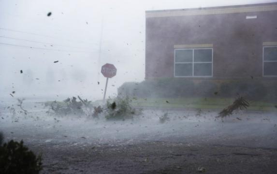
Like all hurricanes, Michael slowed after it made landfall. But the storm didn't weaken as quickly as most, maintaining hurricane-force winds as far as 175 miles inland, Masters said.
Michael was the third-strongest storm ever to hit the United States by minimum central pressure, and the fourth-strongest by wind speed. Because the storm was so strong and moved so quickly, it wasn't just Florida's coastal communities that were affected by towering storm surge -- as high as 14 feet in some places -- and outages from downed power lines.
Tallahassee, which sits 75 miles from the spot Michael made landfall, was spared the brunt of Michael's fury. But Mayor Andrew Gillum said Florida's capital was still hit harder Wednesday than in 2016, when Category 1 Hurricane Hermine took power from 75,000 utility customers. Some 110,000 -- 90 percent of the city -- began Thursday with no power after Michael swept through, Gillum said.
4 There wasn't much time to prepare for Michael.
In September 2017, Hurricane Irma set a record when it spent almost 12 days crawling through the Atlantic as a powerful hurricane. Michael coalesced in just half a week as it zoomed north in the Gulf of Mexico.
Michael's speed made it a difficult storm to prepare for. Gov. Rick Scott, typically known as an aggressive communicator ahead of major storms, didn't tweet about Michael until four days before it hit.
When Irma bore down on the state, Scott was able to warn Floridians for more than a week before it made its landfall just south of Naples. Even with all of those warnings, more than 15 million Floridians lost power during that hurricane.
We don't yet know just how destructive Michael was, but we do know Florida had almost no time to prepare for it.
"The more lead time you have, the more prepared you are," Masters said. "And this one is going to end up potentially causing more loss of life and damage than a storm like Irma."
Copyright 2024 Tampa Bay Times. All rights reserved.


 for 2024 season")


