
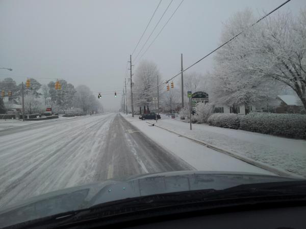
On Sunday morning, we got a couple of reports of possible snow in the Wake Forest and north Raleigh areas, while there was nothing on radar and no indication from computer models that the atmosphere would support a typical snowfall scenario. Nonetheless, Sloane Heffernan drove in from the area and said it appeared there was snow on the ground and crystals in the air, and since that time we've received a couple of photos from the area (shown above) that were taken early Sunday, and the area was impressively whitened during the night and had a very wintry appearance in these shots.
For most of us on Sunday morning, there was a very low deck of shallow clouds and/or some fairly thick fog, with that fog mainly composed of tiny supercooled water droplets. Sometimes in a situation like that, "freezing fog" can occur, in which the tiny droplets freeze on contact with surfaces and create a fairly smooth white icy coating. The appearance in the photos above, however, looks much more like ice crystals settled on the ground, trees, deck railings and so on, and implies that either a slightly deeper cloud capable of producing a light period of snow (yet still shallow enough that weather radar beams passed over top of it undetected), or, perhaps more likely, that the combination of humidity and temperature within the fog in the area led to an "ice fog," with the fog itself composed of tiny ice crystals that accumulated into the coating we see here.
In order to form the classic dendritic, six-sided complex snow crystals that fall in our more typical snows (sometimes as individual small crystals, often as a collection of crystals clumped together into a snowflake), temperatures usually need to be around 14 degrees F or colder, but reports from our viewing area were not that cold yesterday. Instead, they were in the low to mid 20s, a temperature range where the correct amount of water vapor and the right kind of suspended particles of dust, minerals and salt or smoke (called ice nuclei) would more likely lead to crystals shaped like six-sided columns and needles, and possibly some six-sided plate-like crystals. If these formed within the fog and shallow low clouds over a sufficient period, they could have produced the nice-looking effects seen here.
I mentioned to Sloane yesterday that she may have seen ice fog or "diamond dust," which is a similar phenomenon in which tiny suspended ice crystals form in the absence of other precipitation. However, after seeing these photos, I think the "diamond dust" description was probably not the most appropriate, since it classically refers to situations where there are some tiny crystals in the air, but skies are otherwise fair and visibility is not very restricted, and it would be unlikely under those conditions that enough crystals would settle out to give the appearance we see here.
If anyone reading this was in that area early yesterday morning and saw this all occur in process, let me know if it had the appearance of a typical snowfall, or if it was more in the "ice fog" category with crystals floating around and gently settling - also if you noticed the shape of any crystals that fell, it would be interesting to know if they matched the description I gave above for the temperature range that was in place. These kinds of slight mysteries are always interesting to look into!
Copyright 2024 by Capitol Broadcasting Company. All rights reserved. This material may not be published, broadcast, rewritten or redistributed.


