Log in to WRAL.com with one click using your favorite social network:
OR
Log in using your WRAL.com account:


Wrong email/password combination.

Forgot password?

Register with WRAL.com using your favorite social network:
OR
Register for a WRAL.com account using our web form.

9:24 p.m. • 5-21-13

Weather Forecast for Raleigh

  • Wed: Thunderstorm.
    • Hi: 86° F
  • Thu: Thunderstorm.
    • Hi: 83° F
  • Fri: Partly Cloudy.
    • Hi: 76° F

Other Locations

> 7 Day Forecast

Doppler Image

Published: 2010-10-27 10:41:00
Updated: 2010-10-27 14:18:44

Fast-changing weather to bake, shake and frost N.C.


Tornado watch
Tornado watch
print friendly

Quickly changing weather will move North Carolinians from a hot muggy day and a stormy night Wednesday to a frosty morning by Saturday.

Sunshine was helping to raise temperatures Wednesday. The high will be in the mid 80s, likely setting a new daily record.

"It's warm. It's muggy. It's going to feel like summer," WRAL meteorologist Elizabeth Gardner said.

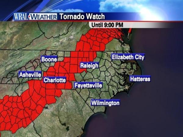
Central North Carolina faces two scenarios that could set off severe weather: an unstable atmosphere combined with heat in Wednesday evening and the passage of a cold front early Thursday.

The heat and instability in the atmosphere could produce severe weather through about 9 p.m. A tornado watch is in effect for 14 counties, including Durham, Orange, Chatham, Granville, Person and Vance counties.

More Info     WRAL WeatherCall 400x300 logo Sign up for WeatherCall alerts

A second round of severe weather could follow when the cold front passes through the state around 3 a.m. or 4 a.m. Thursday.

Strong to severe thunderstorms, isolated tornadoes, damaging wind, heavy rain and flash flooding are possible.

The chance of severe weather and rain will taper off Thursday morning. Humidity will also drop, and Thursday's high will be around 80 degrees.

By Friday, the cold weather will have taken hold, and it will feel like fall again.

"Once we get to the weekend it looks nice. It's going to be much cooler," Gardner said. "By Friday and Saturday, we're certainly expecting some pleasant weather."

Friday will be sunny and clear, with low humidity and a high around 63 degrees. Overnight Friday, temperatures will drop into the mid 30s, and frost could form Saturday morning.

Cooler, sunny weather will prevail throughout the weekend. Saturday and Sunday will see highs in the mid 60s to low 70s.

  • Web Editor: Anne Johnson

48 Comments


WRAL.com welcomes your comments on this story. All comments are moderated prior to publication based on our posting guidelines. Please review them prior to posting and if your message is not approved.

View Comments VIEW ALL 48 COMMENTS

This story is closed for comments. Comments on WRAL.com news stories are accepted and moderated between the hours of 8 a.m. and 8 p.m. Monday through Friday.

Latest Comments
Attention all Global Warming believers. Just google the Vostok ice core data (the bible of global warming) and actually look at the graph. Notice how temperature rises and falls AHEAD of increases or decreases in CO2 levels. Common sense would indicate that CO2 reacts to temperature changes, not the other way around.

This is the kind of weather that makes people sick.

http://instaar.colorado.edu/aaar/browse_abstracts/abstract.php?id=2668

http://www.theregister.co.uk/2010/10/07/solar_as_big_as_people/

I wonder how scientists also say that 90% of the glaciers are growing as well?

Sure, tell us how many scientists are saying glaciers are growing?

View Comments VIEW ALL 48 COMMENTS
WRAL Weather on Twitter
  1. mazewx66: RT @iembot_rnk: #RNK Blowing Rock [Watauga Co, NC] public reports HAIL of quarter size (E1.00 INCH) at 07:35 PM EDT http://t.co/ZEaPlp0MFv
      — Tuesday, May 21, 2013 8:54 PM
  2. nsj: RT @wxtrav: Experimental Tornado Debris Signature path colored by intensity of circulation w/ @NWSNorman damage path in black. http://t.co/…
      — Tuesday, May 21, 2013 6:45 PM
  3. nsj: At least one major news outlet gives the NWS credit for getting the warning out. http://t.co/5ikXGk3GF7
      — Tuesday, May 21, 2013 5:55 PM
  4. nsj: It DID NOT hit without warning. MT @nwsnorman: Slideshow reviewing info from @NWSNorman before […] 5/20/13 tornado http://t.co/ods9kS0qaj
      — Tuesday, May 21, 2013 5:44 PM
  5. wralweather: Forecast: Tonight, partly cloudy, evening showers, low 69°. Tomorrow, thunderstorm, high 86°. http://t.co/RMcYv6WbFE
      — Tuesday, May 21, 2013 5:00 PM
  6. wralweather: A Flash Flood Warning has been issued for Halifax County. http://t.co/sov7VwvLeX #ncwx
      — Tuesday, May 21, 2013 4:48 PM
  7. mazewx66: RT @iembot_rah: #RAH issues Flash Flood Warning for Halifax [NC] till 6:45 PM EDT http://t.co/pH0Tp0yY9w
      — Tuesday, May 21, 2013 4:48 PM
  8. wralweather: RT @nsj: Looks like a wet commute setting up for folks in Fayetteville - rapidly developing thunderstorms E & W of downtown. http://t.co/rP…
      — Tuesday, May 21, 2013 4:45 PM

Follow: WeatherCenter | Maze | Fishel | Gardner | Johnson | Wilmoth