Perdue: N.C. dodged a bullet with Earl
A weakened Hurricane Earl howled past the Outer Banks before daybreak Friday, and by noon, hurricane warnings for coastal counties had been completely canceled or downgraded to a tropical storm warning.
Posted — UpdatedBy noon, hurricane warnings had been completely canceled or downgraded to a tropical storm warning for coastal counties.
"The news is that we’ve dodged a major bullet in North Carolina," Gov. Bev Perdue said early Friday. "The news all over the coast is great."
No injuries or deaths were reported from the storm.
At first light, 1 to 2 feet of water covered roads in the community of Buxton on Cape Hatteras, pushing around plywood, a convenience store ice cooler, a garbage bin and other debris. A Jeep driving down the road had water up to its headlights.
Perdue said there was no serious damage and urged people to get back out for the Labor Day weekend to “have a little fun and spend some money.”
Earl arrived a less menacing storm than it was just a day earlier. By the time it sideswiped North Carolina, its winds had dropped to 105 mph from 145 mph. And at its closest approach, its center passed about 85 miles east of Cape Hatteras — up to 50 miles farther out than forecasters feared.
“Swiping the coast was always better than coming ashore,” said Mark Van Sciver of the North Carolina Emergency Operations Center. “We’re very grateful that the brunt of the storm passed us by.”
All hurricane warnings were discontinued south of Cape Lookout and for the western Albemarle Sound. Warnings remain in effect for Cape Lookout northeastward to the North Carolina/Virginia border, including the Pamlico and the eastern Albemarle sounds.
Earl has minimal impact
Perdue said about 400 people from the coast sought refuge in shelters. Those were closed by noon Friday.
N.C. Highway 12 is closed in both directions south of the Bonner Bridge on Hatteras Island. The bridge crosses Oregon Inlet. The road is often closed by rising tides and blowing sand. It is expected to reopen Saturday morning at 7 a.m.
Transportation officials say many secondary roads on the barrier islands are also closed because of flooding. All state-run ferry service has been suspended.
Hatteras Village, located on the southern end of Hatteras Island within the Cape Hatteras National Seashore, received about 2 feet of water from the Pamlico Sound, officials said.
Ernie Foster, charter boat operator and member of the North Carolina Coastal Federation, said people there could get around only by boat until the tide receded.
"For today, there’ll be no movement. Everybody’s hunkered down," he said. "Right now you could not drive a car around. You’d stall in the water."
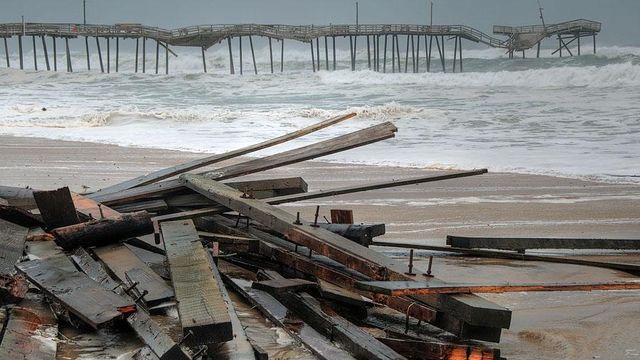
Cape Hatteras Fishing Pier, referred to locally Frisco Pier, sustained significant damage from strong waves.
Ocracoke business owner Scott McNally said the area had three feet of flooding. A WRAL crew who flew over the island in Sky 5 reported minor flooding.
Hyde County spokeswoman Jamie Tunnell says N.C. Highway 12 is open to four-wheel-drive traffic and might be open to all traffic later Friday. Reopening the road will help island residents, but visitors can’t reach it yet because the U.S. Coast Guard must first approve re-starting ferry service from Swan Quarter and Cedar Island.
In Atlantic Beach, the storm damaged the pier behind the Sheraton Hotel. Heavy surf knocked away some supports under the pier, though it is still standing. The pier is blocked off with tape.
About 20 tires washed up on Atlantic Beach on Friday morning. There was speculation that the tires were part of an artificial reef that provided a habitat for fish, but was broken up in the storm.
In Nags Heads overnight, the rain lashed against window panes, and howling gusts bent the tops of small trees and whipped around beach grass on dunes.
Town Manager Cliff Ogburn said that Nags Head got "very minimal" damage, such as broken shingles and broken steps on boardwalks over dunes. The ocean did not wash over onto main roads, but nearly 4 inches of rain fell, more than expected.
The Coast Guard planned an airplane flyover of the Outer Banks and were prepared for search-and-rescue helicopter flights.
Van Sciver said the wind damage caused power outages, mostly in Hyde County, where at the storm's peak about 5,000 customers were without service. Other utilities reported more than 1,600 customers without service in Dare County and farther south around New Bern, Morehead City, Jacksonville and Kinston.
Progress Energy's largest outage, to 2,500 customers in Jacksonville, occurred when a tree fell on top of a power line and broke the utility pole. Service has been restored.
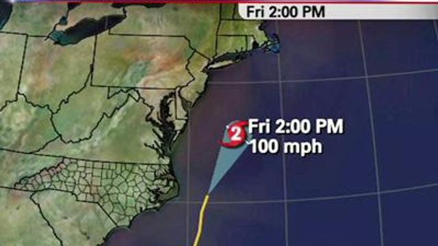
Hurricane Earl swirled away from North Carolina and north into the Atlantic by mid-morning Friday.
"We're delighted to ask him to leave," Perdue said. "The sooner, the better."
During its march up the Atlantic, Earl could snarl travelers’ Labor Day weekend plans, with several flights already canceled.
Forecasters expected Earl to remain a large hurricane as it swirled its way up the Eastern Seaboard toward New England by late Friday. Forecasters said it would away from New Jersey and other mid-Atlantic states but pass very close to Long Island, Cape Cod and Nantucket, which could get gusts up to 100 mph.
The most likely place Earl will make landfall is on Saturday in western Nova Scotia, Canada, where it could still be a hurricane, said hurricane center deputy director Ed Rappaport.
Farther up the coast, governors in Massachusetts and Rhode Island declared states of emergency, joining Virginia and Maryland.
Massachusetts Gov. Deval Patrick urged people living in low-lying areas prone to flooding to consider leaving their homes by Friday afternoon. Officials on Nantucket Island, Mass., planned to set up a shelter at a high school on Friday.
“We’re asking everyone: Don’t panic,” Patrick said. “We have prepared well, we are coordinated well, and I’m confident that we’ve done everything that we can.”
In New York City, officials were on alert but said they expected to see only side effects of the storm — mostly rain and high winds, with possible soil erosion on the beaches and flooding along the oceanside coasts of Brooklyn and Queens.
Much of New England should expect strong, gusty winds much like a nor’easter, along with fallen trees and downed power lines, forecasters said.
“This is the strongest hurricane to threaten the Northeast and New England since Hurricane Bob in 1991,” said Dennis Feltgen, a meteorologist with the National Hurricane Center.
• Credits
Copyright 2024 by WRAL.com and the Associated Press. All rights reserved. This material may not be published, broadcast, rewritten or redistributed.


