Outer Banks could feel effects of Hurricane Earl
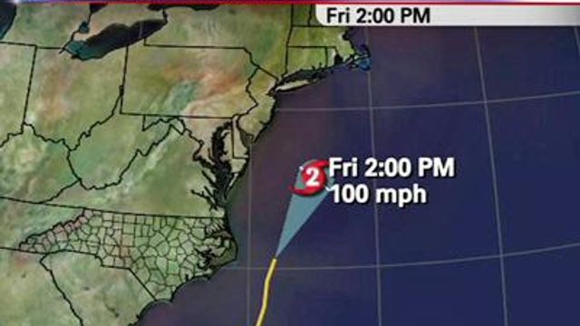
The latest track has part of the storm's forecast fan crossing the Outer Banks on Thursday.
Posted — UpdatedAs of 3 p.m., the Category 3 storm, which formed Sunday, had sustained winds of 125 mph and was likely to keep growing as it moved northwest.
It could possibly become a Category 4 hurricane, with winds of at least 131 mph, by the middle or later part of the week, according to the U.S. National Hurricane Center.
The latest track has part of the storm's forecast fan crossing the Outer Banks on Thursday, when the storm is expected to weaken slightly to a Category 3.
"It's been trending a little farther to the west as we watch each run come through," WRAL meteorologist Elizabeth Gardner said. "At this point, if it doesn't trend any farther to the west, we're looking at the potential for rip current danger, heavy surf beach erosion and possible overwash on the Outer Banks."
The Cape Hatteras area has a 40 percent chance of seeing tropical storm-strength winds at or above 39 mph.
Further south, beaches in Brunswick and New Hanover counties won't feel as much of an impact, but there is a 20 percent chance of tropical storm-strength winds in the area.
The storm is likely to continue toward the northeast late Thursday or early Friday.
"The one bright side to all of this is that it's probably not going to have a major impact on the Labor Day weekend," Gardner said. "Whatever damage it does could put a damper on it, but in terms of the storm being there for the weekend, it's going to move on out of here in time for folks heading to the beach."
Meanwhile Monday, hurricane warnings were in effect for the Carribbean, including Antigua, Barbuda, St. Kitts, the British Virgin Islands and the U.S. Virgin Islands.
In Antigua, powerful wind and rain destroyed at least one home and at least eight people had to be evacuated, though there were no reports of critical injuries. Emergency response officials said about 350 people were in shelters. Local weather authorities reported at least 5 inches of rain and 10-foot waves.
In St. Maarten, the storm toppled trees and knocked out electricity to much of the island but there were no reports of serious damage. Heavy gusts of wind swirled debris across streets that were empty due to a government-imposed curfew.
Alisha Daya, a 24-year-old tourist from Milwaukee, said she wore earplugs Sunday night but still had trouble sleeping because of the noise from the wind and crashing waves at the Oyster Bay Beach Resort in St. Maarten.
“It was loud because we were right on the ocean,” said Daya, who said the storm will keep her and her parents and boyfriend from leaving the island as planned on Monday although the worst seemed to have passed. “Some furniture is flying around, but everything seems to be OK.”
Cruise lines diverted ships to other ports in the Caribbean and Mexico as a customary precaution for tropical weather. Antigua’s V.C. Bird International Airport closed, and regional airlines suspended flights.
Earl has grown rapidly in strength, fueled by warm ocean temperatures of 86 degrees.
Meanwhile, the Category 1 Hurricane Danielle was weakening far out over the north Atlantic.
And further out in the mid-Atlantic, showers and thunderstorms were gradually becoming better organized in association with a low pressure system located about 1,050 miles east of the lesser Antilles.
A tropical depression could form and within the next 24-48 hours could become Fiona, the sixth named storm for the Atlantic hurricane season.
Copyright 2024 by WRAL.com and the Associated Press. All rights reserved. This material may not be published, broadcast, rewritten or redistributed.


