Hanna's approach yields tornado watches
Conditions are ripe for tornadoes accompanying the sweep of Tropical Storm Hanna across North Carolina, the National Weather Service has determined. The first tornado watches were issued just after 4:30 p.m. and extend north to south in the counties directly in the storm's expected cone of impact.
Posted — UpdatedThe first tornado watches were issued just after 4:30 p.m. and extend north to south in the counties directly in the storm's expected cone of impact. Those watches extend until 5 a.m.
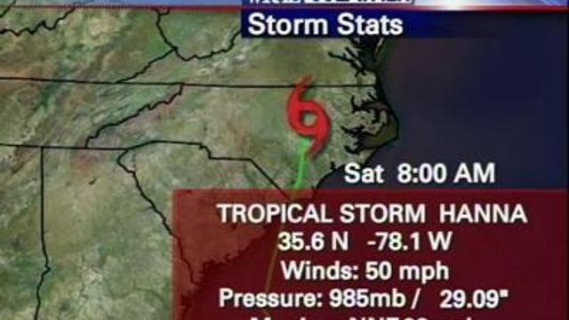
At 5 p.m., Hanna was blowing at a maximum of 69 mph and advancing toward the Carolinas at almost 20 mph.
"The first really good band" of rain from had passed through Wilmington by 3 p.m., WRAL Chief Meteorologist Greg Fishel said. Those showers quickly moved inland and were being felt as far west as Greensboro.
"It's outer bands, but some of that is just easterly flow coming in off the Atlantic," Fishel explained. "This thing is still way, way down there."
Hanna's landfall is expected overnight somewhere between Myrtle Beach and Charleston, S.C.
The storm could produce rainfall accumulations of 3 to 7 inches from coastal South Carolina northward through North Carolina into central Virgina, Maryland and southeastern Pennsylvania.
Isolated maximum amounts of 10 inches are possible.
Isolated tornadoes are possible Friday night over the coastal areas of South and North Carolina.
"This is not just going to be a coastal issue," Easley said. "The wind and rain are going to be far spread."
Some Southeastern states, including North Carolina, declared emergencies Thursday, and officials urged residents to head inland.
Forecasters expected Hanna to strengthen slightly before making landfall early Saturday.
"The storm is moving fast now," said WRAL Meteorologist Elizabeth Gardner. "Twenty miles per hour – that is fast for a tropical storm."
State of emergency
Easley declared a state of emergency and activated the National Guard and water rescue teams, and he urged residents to prepare for possible hits from Tropical Storm Hanna and Hurricane Ike.
"It now appears Hanna will be a Category 1 hurricane when it hits the North Carolina coast Saturday morning," Easley said Thursday.
The twin threats of Hanna and Ike prompted Easley to issue the state of emergency, he said.
"It lets me legally activate all the resources the state has, (and) it's the first step to asking the federal government for assistance," Easley said.
The governor placed 270 National Guard members, 12 of the state's Swift Water Rescue teams and 144 state troopers on standby for immediate deployment.
"We also, for this particular storm, have six Blackhawk helicopters available both before and after the winds subside," Maj. Gen. William E. Ingram Jr., adjutant general of the North Carolina National Guard, said.
An emergency, bilingual hotline (1-888-835-9966 or TTY 1-877-877-1765) began 24-hour operations at 10 a.m. Friday. The hotline will provide weather updates, shelter locations, highway closings and, later, act as a referral service for those in need of help.
Forecasters could soon be getting less information about approaching storms, because some weather buoys have been removed or repositioned due to a lack of federal funding. Two buoys off Sunset Beach have been removed.
"It's the first information we get as the storm approaches," WRAL meteorologist Mike Maze said. "It's certainly disconcerting."
Hanna wasn't the only tropical weather system to watch.
Farther out to sea, Hurricane Ike was Category 3 strength, with winds near 120 mph, as it spun westward across the Atlantic. It could arrive in the Bahamas on Sunday.
Tropical Storm Josephine was out there, too, spinning around with winds at about 50 mph, as of Friday morning.
Emergency plans laid across state
Counties across the state made emergency plans and considered evacuations, while others opened shelters.
Tracking Hanna
Green dots on the map (below) represent counties that have announced emergency plans for Hanna. Blue dots show where WRAL news crews are throughout the state. The sun and clouds symbols show the locations of weather-data monitoring stations. Click those for updated local temperature, rainfall and wind statistics.
• Credits
Copyright 2024 by Capitol Broadcasting Company. All rights reserved. This material may not be published, broadcast, rewritten or redistributed.


