Looks like no way for Fay rain in western N.C.
The National Hurricane Center gives the state a 5 to 10 percent chance of getting tropical-storm-force winds in the next five days.
Posted — Updated
A high-pressure system settling in over the eastern United States will force Fay to make a turn at the Florida-Georgia border after it heads northeast, according to the National Weather Service.
Fay could stall over Georgia and will likely steer away from central North Carolina. The storm had been expected to reach the mountains by Saturday.
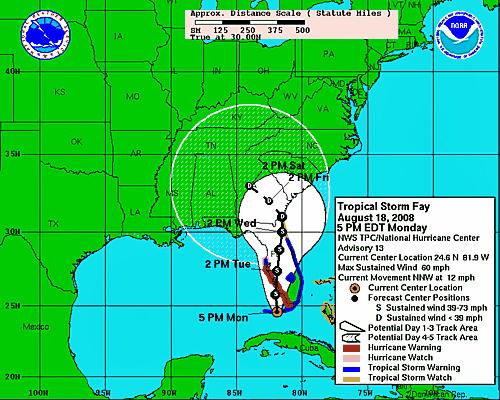
At 11 p.m. Tuesday, the center of the storm was about 30 miles south-southwest of Melbourne and forecasters expected it to head north-northeast at about 5 mph overnight.
Hopes had been high that Fay would bring relief for drought-ravaged sections of North Carolina and South Carolina.
Chances are dwindling that the storm will provide much rain this week, although it could turn back toward the state if the high-pressure system weakens, forecasters said.
While no computer models have the storm affecting North Carolina, some models show it reentering the Atlantic Ocean. Fishel said the storm could “explode” over warm waters and cause major problems for Florida and Georgia.
Northern Florida and southern Georgia could potentially receive up to 20 inches of rain, Fishel said.
The National Hurricane Center gave North Carolina a 5 percent to 10 percent chance of getting tropical-storm force winds in the next five days.
Officials said that so far this year, 20.16 inches of rain have fallen at Asheville Regional Airport. The normal amount is 30.57 inches.
State water-planning official Linwood Peele said drought conditions in western North Carolina came earlier than last year, and 2007 saw a record drought. The state's drought monitor lists 18 western counties in the most severe category, exceptional drought.
Tropical storms are good drought-busters, said Doug Miller, an associate professor of atmospheric sciences at the University of North Carolina at Asheville.
"We would almost have to have a repeat of the fall of 2004 to have a hope to get back to normal, and that was an exceedingly rare event," Miller said. That year, remnants of two hurricanes caused extensive flooding in western North Carolina.
"If Fay stays away, we could have rain-free conditions here for the next week," Fishel said. He added that in an "ironic" move, Fay could bring remnant rainfall to the state in six to seven days.
Fay's conditions caused Democratic presidential candidate Barack Obama to cancel an unannounced trip through eastern North Carolina Tuesday morning. Obama had planned to fly from Orlando, Fla., to Kinston, N.C., and make several stops on his way to speak in Raleigh Tuesday night.


• Credits
Copyright 2024 by WRAL.com and the Associated Press. All rights reserved. This material may not be published, broadcast, rewritten or redistributed.


