Log in to WRAL.com with one click using your favorite social network:
OR
Log in using your WRAL.com account:


Wrong email/password combination.

Forgot password?

Register with WRAL.com using your favorite social network:
OR
Register for a WRAL.com account using our web form.

1:30 p.m. • 5-20-13

Weather Forecast for Raleigh

  • Today: Thunderstorm.
    • Hi: 76° F
  • Tue: Thunderstorm.
    • Hi: 82° F
  • Wed: Partly Cloudy.
    • Hi: 86° F

Other Locations

> 7 Day Forecast

Doppler Image

Published: 2008-05-29 11:48:00
Updated: 2008-05-29 18:28:49

Drought intensifies in western N.C.


May 29, 2008, drought report
print friendly

While much of eastern North Carolina has pulled out of the historic drought that has gripped the state for the past year, conditions in the western part of the state are worsening, according to a new state report.

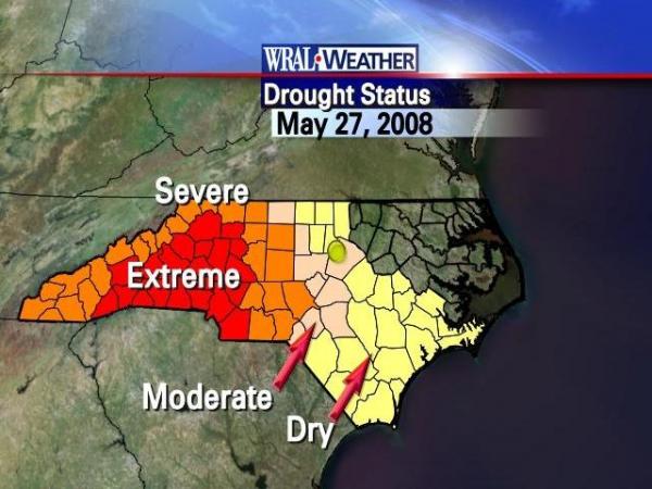
Twenty-eight counties, stretching from Charlotte to the Yadkin Valley, are experiencing extreme drought conditions, compared with 15 counties a week ago, the state Drought Management Advisory Council said in a report issued Thursday.

Another 18 counties in the western half of the state are in severe drought, the report said.

“Rain has been plentiful in the eastern part of the state, but parts of the Piedmont and western North Carolina have received only half their normal rainfall,” Gov. Mike Easley said in a statement. “We learned a lot about conserving water during the past year, and we need to continue working together to make sure we have adequate water resources today and in the future.”

Most of the Triangle remains classified as "abnormally dry," although most of Chatham County, all of Lee County, western Harnett County and extreme southwestern Wake County are in a moderate drought.

During a drought council meeting Thursday, state climatologists said weather forecast models are uncertain about rain for the near future, meaning the state could face another hot, dry summer.


10 Comments


WRAL.com welcomes your comments on this story. All comments are moderated prior to publication based on our posting guidelines. Please review them prior to posting and if your message is not approved.

View Comments VIEW ALL 10 COMMENTS

This story is closed for comments.

Latest Comments
You are correct flashlight, but the water being dumped over the dam is now well in excess of the normal flow down the Neuse. It is truly being wasted, not conserved. There is no shortage of ocean water. (Isn't that what Algore has been telling us?)

The water is used by municipalities downstream, then it goes to the ocean.

Precisely cherokee. Continued rampant growth is going to keep dropping the aquifers. Unfortunately for Gulf Coast folks, what we need is several Gulf storms to sweep up through Northern GA, western NC/VA & eastern TN. It will take more than just one or two to do it.

One clarification for amlebede, we have already reached the point where the lakes are full. If fact they are overflowing. Falls Lake has been over a foot higher than normal.

The Corps of Engineers is dumping over 550 million gallons a day of water to the ocean to try and get the level down to 251.50 feet (normal). We still have water restrictions in Raleigh, but they are not there for conservation anymore. It is no more wasteful for someone use water than it is for it to be dumped in the ocean.

It's not the recent rains that are the measure. It's the level of the ground water.

To restore those levels will take an extended period of extraordinary wetness.

Basically, all the recent rains have done is fill the lakes and allow us to hold even.

View Comments VIEW ALL 10 COMMENTS
WRAL Weather on Twitter
  1. nsj: Tornadoes have done a lot of bad recently, but in one place, they've built an indoor tornado to help save lives. http://t.co/gWWLHXWVjH
      — Monday, May 20, 2013 1:17 PM
  2. nsj: Adding insult to injury - DD5K now showing an intense rain shower right over the side of the I-40-closing accident near I-440.
      — Monday, May 20, 2013 12:42 PM
  3. nsj: RT @NWSNorman: Preliminary information from NWS survey team near Shawnee indicates EF4 damage. Surveys are ongoing. more details later. #ok
      — Monday, May 20, 2013 11:49 AM
  4. wralweather: Today's air quality forecast: green (Good)
      — Monday, May 20, 2013 11:30 AM
  5. WRALweathergal: Heaviest rain is in the sandhills this morning. It's moving northward toward the triangle. Plan extra time for your commute.
      — Monday, May 20, 2013 6:02 AM
  6. wralweather: Forecast: Today, thunderstorm, high 76°. Tonight, showers/storms moving out, low 65°. http://t.co/RMcYv6WbFE
      — Monday, May 20, 2013 6:00 AM
  7. WRALweathergal: Heave rain in spots this morning. Keep it tuned to #wral for the latest look at where traffic is backing up.
      — Monday, May 20, 2013 5:43 AM
  8. nsj: So, I appreciate TWC punting scheduled programming for live coverage, but with regular programming titles like this… http://t.co/oeehYQh3LN
      — Sunday, May 19, 2013 11:10 PM

Follow: WeatherCenter | Maze | Fishel | Gardner | Johnson | Wilmoth