Weather
Severe Thunderstorms, Wind Damage Possible Friday
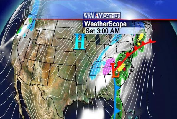
A storm system that brought snow to Texas and tornadoes to Florida is working its way north and east Friday, with the Triangle in its track.
Posted — Updated
RALEIGH, N.C. — A storm system that brought snow to Texas and tornadoes to Florida worked its way north and east Friday. The brunt of the storm will probably be felt to the east of the I-95 corridor, bypassing a direct hit on the
It's been a wet Friday so far, with showers scattered across the region, WRAL Meteorologist Elizabeth Gardner reported. As afternoon turns to evening, the path of low pressure will track just to the west of the Triangle, bringing heavy rain and high winds overnight. Some parts of the region could see as much as 2 inches of rain, and isolated tornadoes are possible.
Heavy rains were falling Friday across the western part of the state, with accumulations of up to an inch. Forecasters with the National Weather Service said a combination of cold air and moisture moving into the far western corner of the state could turn to snow overnight and continue through Saturday afternoon.
The heaviest snow is expected Friday night and early Saturday, when 4 to 5 inches could fall within six or seven hours, said Joe Ammerman, a weather service meteorologist in Louisville, Ky.
Closer to home, the greatest threat is from wind damage, WRAL Chief Meteorologist Greg Fishel said. He explained the factors that could make Friday's storm system more severe than the one that moved through the area earlier in the week.
"This is a powerful, powerful system in the upper atmosphere, and not only are we going to have strong winds aloft this time, like we had Tuesday night, but this time, it looks like the atmosphere will be even more unstable," Fishel said.
As the system moves out Saturday, a "howling northwesterly wind flow" will move in, producing gusts topping out between 40 and 50 mph, Fishel predicted.
• Credits
Copyright 2024 by Capitol Broadcasting Company. All rights reserved. This material may not be published, broadcast, rewritten or redistributed.


