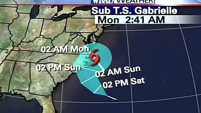
Gabrielle Gains Power While Advancing on Coast
Tropical Storm Gabrielle brought rain to the Outer banks Sunday morning, and it grew slightly stronger as it moved toward landfall later Sunday.
Posted — UpdatedGabrielle's center was expected to pass over or near the Outer Banks late Sunday morning or early Sunday afternoon, and data from an Air Force Reserve hurricane-hunter plane showed the storm had strengthened somewhat as it made a run for the coast. WRAL Meteorologist Mike Moss said the storm center was moving across the warm Gulf Stream about dawn Sunday and could pick up energy there.
Its outer rain bands reached the coast Saturday night, and rains were heavy at times on the Outer Banks on Sunday morning.
miles south-southeast of Cape Lookout. The storm was moving about 10 mph toward the north-northwest.
At Atlantic Beach, Carteret County Manager John Langdon the county would ramp up staffing if necessary, but was in stand-by mode Sunday morning.
"This doesn’t compare much with a northeaster at all, so this isn’t too much," Langdon said as rain pelted the beach. However, it "wouldn’t be real bright to be swimming or surfing" because of storm currents, Langdon said .
Late Saturday, the storm's thunderstorms and center began to reunite, which could signal intensification of the storm. As winds aloft lessen Sunday morning and the storm moves over warmer water, a brief window for slight intensification exists.
"Until it makes some kind of landfall, we won't discount the fact that it could have additional strengthening," WRAL Meteorologist Mike Maze said.
Gabrielle wobbled to the north for several hours Saturday, but it appeared to get back its bearings later in the day. Overall, Maze described Gabrielle's movement on Saturday as "rather erratic."
The National Weather Service's rain forecast was reduced to 1-3 inches along the coast, with up to 5 inches in unpredictable spots of heavier downpours.
As winds along the shore increase Sunday, there will be a storm surge of 2 to 3 feet, the National Hurricane Center in Miami said.
Increasing ocean swell from Gabrielle will combine with high astronomical tides to produce dangerous rip currents across area beaches through the weekend, forecasters said.
The Pamlico and Neuse rivers will have storm surges of 2 to 4 feet, the Morehead City weather office said. Along the south side of Albemarle Sound, water-level rises of 1 to 2 feet are expected. High tides will be around 6 a.m. and 7 p.m.
As for the Triangle, forecasters said the region's best chance for rain will be on Sunday, but Maze said the storm's effect on the Triangle will be "negligible."
Gabrielle "bears watching, especially along the coastal sections, but at this point, if you're looking for rain in the central part of the state, with that track moving to the east, that diminishes that chance even more," WRAL Meteorologist Kim Deaner said Saturday evening.
Greenville and Edgecombe County may experience some winds of tropical storm force-strength.
Throughout the week, the ocean temperatures have averaged around 82 degrees Fahrenheit, one of the key thresholds for tropical development.
Condition X-ray also means that owners of smaller boats were urged to take them to inland marinas, and boats that can be put on trailers should be taken to safe areas.
Copyright 2024 by WRAL.com and the Associated Press. All rights reserved. This material may not be published, broadcast, rewritten or redistributed.


