Meteorologist: 'Waiting and Watching' on Atlantic Storm System
A high-pressure system off the New England coast will help determine whether a storm system in the Atlantic will bring rain to North Carolina this weekend.
Posted — UpdatedIn the Triangle, there were cautious hopes that the low-pressure system that is far out to sea might develop into a tropical depression and bring much-needed rain this weekend. As of Wednesday night, however, there was "nothing tropical at all" about the storm system, WRAL's chief meteorologist Greg Fishel said.
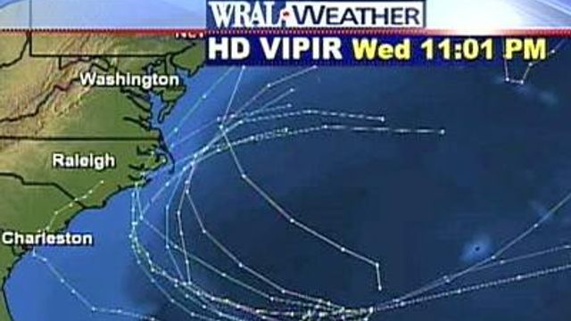
The motion of a high-pressure system over the New England coast will determine whether the low-pressure system moves on-shore into North or South Carolina. Meteorologists predicted the high-pressure system will move to the northeast, and its clockwise winds could push the low-pressure system west.
If that happens, the low-pressure system could intensify, and major effects of the storm could be felt in North Carolina by late Saturday or early Sunday.
On Wednesday night, though, only one computer model of the 16 used by WRAL meteorologists showed the storm hitting Charleston and the remnants moving up into Raleigh. Most models had the storm moving along the Outer Banks, while others showed it staying off-shore completely.
"There's a lot of uncertainty on the direction of this (storm)," Maze said.
"We want to emphasize the variability (that's occurred) every six hours when the new models update has been big," Fishel said.
Fishel predicted that major intensification of the system will begin on Friday and continue through Saturday afternoon. It will be at least 24 hours before we seen any tropical development in the system, Fishel said.
However, Fishel cautioned that predictions of the storm's developing into a tropical or sub-tropical system remain "speculative."
A hurricane-hunter aircraft flew out from Pensacola, Fla., to collect data and monitor the status of the low-pressure system Wednesday afternoon.
The aircraft found that the system was "very disorganized" and showed "no signs of tropical development," Maze said. Lots of dry air west of the center could also work against any tropical development.
Factors in favor tropical development include: a center of circulation with surface winds at 38 mph, lessening winds aloft, warm water temperatures and a burst of thunderstorm activity east of the storm center.
If the system were to become a tropical storm, it would be named Gabrielle.
Despite the uncertainty about the low-pressure system's future, it has already forced the postponement of at least one event. Organizers pushed the 2007 Atlantic Beach King Mackerel tournament back from this weekend to Oct. 18-20.
The rain would be a welcome sight for many in North Carolina, even as winds or flooding from a very heavy storm could pose problems. Officials have said 12 to 18 inches of rainfall would help ease drought conditions statewide.
After an early named storm in May, the first two months of the Atlantic hurricane season, June and July, saw average activity, with two named storms but no hurricanes. August was about average, with two named storms. One became a hurricane, Dean, which grew into a Category 5 storm before hitting Central America.
In September, Central America has already taken a one-two punch.
Hurricane Felix roared ashore in Nicaragua as a Category 5 storm late Tuesday. Winds topping out at 160 mph tore trees from the ground and rooftops off homes and buildings. Nicaraguan authorities said at least 18 people have died in the storm so far and dozens more were missing on Wednesday night.
Residents fear worse death and destruction as Felix is expected to drop up to 25 inches of rain on mountainous parts of Nicaragua and Honduras.
Hours after Felix hit, Hurricane Henriette made landfall on the region's west coast and punished resorts on the southern tip of Baja California. Henriette forced airports to close and left tourists to face driving rain and 15-foot waves but caused no deaths as it headed toward mainland Mexico.
• Credits
Copyright 2024 by Capitol Broadcasting Company. All rights reserved. This material may not be published, broadcast, rewritten or redistributed.


