Weather
Strong Storms Move Through Triangle Area
An approaching cold front is expected to bring scattered showers and thunderstorms across the Triangle area Wednesday evening.
Posted — Updated
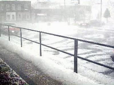
RALEIGH, N.C. — An approaching cold front brought scattered showers and thunderstorms across the Triangle area Wednesday evening.
The National Weather Service said reports of hail, sometimes as large as baseballs, began coming in from Nash, Granville and Edgecombe counties about 3:45 and continued until almost 6 p.m. Most reports were of smaller hail, however.
The weather service also had reports of flash flooding on N.C. 43 in Nash County and on several city streets on Oxford.
WRAL Chief Meteorologist Greg Fishel said a stabilizing atmosphere should allow for spotty areas of rain and drizzle late Wednesday evening into Thursday morning.
Much colder air was on the way for into central North Carolina overnight, NWS forecasters said. Temperatures Wednesday evening were expected to remain in the upper 60s to lower 70s, dropping into the upper 40s and lower 50s by daybreak.
Copyright 2024 by Capitol Broadcasting Company. All rights reserved. This material may not be published, broadcast, rewritten or redistributed.


