Afternoon thunderstorms possible on 'typical August day'
A cold front passing over central North Carolina will combine with high temperatures in the low 90s on Wednesday afternoon to produce the chance for isolated severe weather, said WRAL meteorologist Elizabeth Gardner.
Posted — Updated
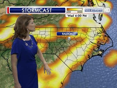
Eastern North Carolina has an elevated risk for severe weather, according to the Storm Prediction Center.
Late Tuesday, the National Weather Service issued tornado warnings for Warren and Halifax counties that lasted less than 30 minutes.
Conditions in the Littleton and Warrenton areas were severe, but no tornado touchdowns have been confirmed.
"At this point, it wasn't clear if it was a tornado or damaging straight line winds," Gardner said. "But it came in as a wind damage report, so we're thinking it was probably not a tornado."
Conditions on Wednesday afternoon will be similar, with areas from the Triangle eastward seeing thunderstorms, damaging wind gusts, large hail and a slim chance of a tornado, Gardner said.
Skies will clear Thursday as the cold front moves out, allowing temperatures to climb back into the mid-90s Friday and Saturday.
"We're going to be nice and quiet Thursday, and then we're going to see those mid-90s return for the last couple of days of the week," Gardner said. "But we actually have a cooling trend on the way that will impact a lot of the country."
By Sunday and early next week, temperatures will dip into the 60s overnight and top out in the mid-80s in the afternoon.


• Credits
Copyright 2024 by Capitol Broadcasting Company. All rights reserved. This material may not be published, broadcast, rewritten or redistributed.


