Humidity, showers, storms on repeat this weekend
A cold front that stalled over central North Carolina late Friday will spawn showers and thunderstorms throughout the day Saturday, with some areas seeing locally heavy downpours, said WRAL meteorologist Mike Moss.
Posted — Updated
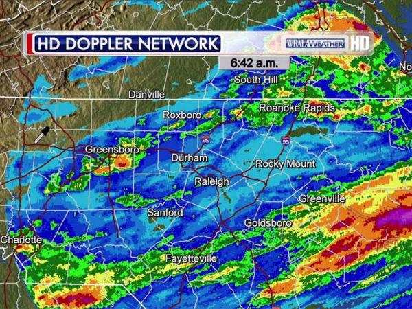
On Friday, bands of showers and thunderstorms rolled through the area, dropping an inch or more of rain on many parts of Wake, Warren, Cumberland and Vance counties. A pocket of Vance County saw 2 to 3 inches.
In Fayetteville, rainfall totaled about an inch, but as much as three inches fell in areas south and west of the city.
Moss said Saturday's shower and storm activity would mimic Friday's.
Scattered showers and thunderstorms will likely pop up in the afternoon, though a stray shower is possible Saturday morning, Moss said.
"A couple of them could produce gusty winds here and there, and some localized heavy downpours," he said.
WRAL Chief Meterologist said rainy conditions could keep people indoors for much of the weekend.
"Don't count on Saturday being the type of day where you can hang around the pool until the afternoon thunderstorms pop up," Fishel said. "This stuff is going to be around on-and-off all day long."
High temperatures will dip back into the 80s Saturday afternoon, but high humidity and an unsettled air mass won't provide much relief from uncomfortable summer heat.
"This frontal zone is separating two very different air masses," Fishel said. "Temperatures in the northeast were in the 60s and 70s Friday while the Triangle got into the 90s again. It's still going to be humid as all get out Saturday and Sunday."
Sunshine will peek through the clouds on Sunday as high temperatures climb back toward the 90-degree mark, but afternoon showers and thunderstorms will remain in the forecast. Any storms that do develop could dump some heavy rain and create localized flooding.
"Although there is cooler air to the north of this front, we're not going to see any of it," Fishel said. "We'll be back into the mid-90s by early next week and close to 100 degrees again by next weekend."


• Credits
Copyright 2024 by Capitol Broadcasting Company. All rights reserved. This material may not be published, broadcast, rewritten or redistributed.

 for 2024 season")


