Log in to WRAL.com with one click using your favorite social network:
OR
Log in using your WRAL.com account:


Wrong email/password combination.

Forgot password?

Register with WRAL.com using your favorite social network:
OR
Register for a WRAL.com account using our web form.

6:12 a.m. • 5-22-13

Weather Forecast for Raleigh

  • Today: Thunderstorm.
    • Hi: 86° F
  • Thu: Thunderstorm.
    • Hi: 83° F
  • Fri: Partly Cloudy.
    • Hi: 76° F

Other Locations

> 7 Day Forecast

Doppler Image

Published: 2012-05-04 10:20:00
Updated: 2012-05-04 23:29:59

Friday's fast storms presage weekend weather


Lightening
Lightening
print friendly

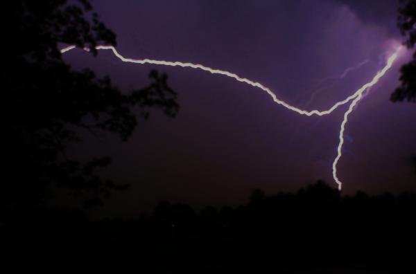
Dispatchers in Halifax County took calls Friday evening about power knocked out and trees toppled by fast-moving thunderstorms. A tree fell across White Swan Road about a mile east of Enfield, authorities said, but no one was injured.

The storms signaled the end of a blast of heat that bathed the Triangle in 90-degree temperatures over the past few days.

Much more normal temperatures will follow a cool front into the area this weekend, according to WRAL Chief Meteorologist Greg Fishel.   Slideshow     rainbow a-Maze-ing weather photos

"It looks cooler and wetter this weekend, with Saturday pretty rainy from mid-day on," Fishel said.

WRAL meteorologist Mike Maze said Saturday was shaping up to be a wet one from about noon until 8 or 9 p.m. "We'll see a heavy rain, some lightning and the potential for winds gusting in excess of 50 mph," he said.

If the clouds clear by midnight Saturday, stargazers will get a double treat, with the ETA Aquarid meteor shower hitting its peek and the "super moon," a popular name for the "perigee moon," out in full force.

Because the moon's orbit is more of an oval than a circle, the moon will be closer to the Earth than normal and appear about 15 percent bigger and 30 percent brighter Saturday night. 

Sunday will be mostly dry, Fishel said, but a fair amount of clouds will dominate and temperatures will stay much cooler, with highs only around 80 degrees.

"Sunday will be a distinct difference from what we've seen over the past couple of days," Maze said, pointing to a forecast high that barely tops 80 degrees.


9 Comments


WRAL.com welcomes your comments on this story. All comments are moderated prior to publication based on our posting guidelines. Please review them prior to posting and if your message is not approved.

View Comments VIEW ALL 9 COMMENTS

This story is closed for comments. Comments on WRAL.com news stories are accepted and moderated between the hours of 8 a.m. and 8 p.m. Monday through Friday.

Latest Comments
Did I miss something or has spring come and gone?

all day the article on the main page was heat continues thru the weekend

Glad to see the Fish back, now we can get some reliable forecasting!!!!!!!

I suppose that "hitting its peek (sic)" might be a clever play on words but it is probably just poor editing.

Amby, I'll bring the beverages :) I've got a ton to do this weekend, can't wait to get after it.

View Comments VIEW ALL 9 COMMENTS
WRAL Weather on Twitter
  1. wralweather: Forecast: Today, thunderstorm, high 86°. Tonight, mostly cloudy, showers?, low 66°. http://t.co/RMcYv6WbFE
      — Wednesday, May 22, 2013 6:00 AM
  2. nsj: RT @BadAstronomer: Oh for criminy’s sake, Internet. GIF is pronounced “Ekke Ekke Ekke Ekke Ptangya Ziiinngg!” #duh
      — Wednesday, May 22, 2013 1:41 AM
  3. nsj: Hey, RNK - everything OK up there? RT @iembot_rah: #RAH Administrative Message (ADM) http://t.co/DRvIBqKQEU
      — Wednesday, May 22, 2013 1:32 AM
  4. nsj: RT @GarySzatkowski: Great lunchtime meeting today with @nsj discussing where the weather enterprise goes from here in a post-Sandy & post-M…
      — Wednesday, May 22, 2013 1:13 AM
  5. mazewx66: RT @iembot_rnk: #RNK Blowing Rock [Watauga Co, NC] public reports HAIL of quarter size (E1.00 INCH) at 07:35 PM EDT http://t.co/ZEaPlp0MFv
      — Tuesday, May 21, 2013 8:54 PM
  6. nsj: RT @wxtrav: Experimental Tornado Debris Signature path colored by intensity of circulation w/ @NWSNorman damage path in black. http://t.co/…
      — Tuesday, May 21, 2013 6:45 PM
  7. nsj: At least one major news outlet gives the NWS credit for getting the warning out. http://t.co/5ikXGk3GF7
      — Tuesday, May 21, 2013 5:55 PM
  8. nsj: It DID NOT hit without warning. MT @nwsnorman: Slideshow reviewing info from @NWSNorman before […] 5/20/13 tornado http://t.co/ods9kS0qaj
      — Tuesday, May 21, 2013 5:44 PM

Follow: WeatherCenter | Maze | Fishel | Gardner | Johnson | Wilmoth