
We're still a couple of weeks away from the end of winter, as commonly defined by the occurrence of the vernal equinox, but "winter" in terms of the meteorology and climatology involved is usually defined for record-keeping purposes to the calendar months of December, January and February.
The winter just passed was influenced by a moderate to strong El Nino pattern, which tilts the odds across much of our state toward cooler-than-normal temperatures and slightly toward greater than normal precipitation, but was also characterized by several other pressure oscillations and patterns (for example, the Arctic Oscillation and Pacific North America pattern) that were dominated by their "cold" phases for the eastern U.S. through the great majority of the winter.
With that as a prelude, here are a few of the statistics from the chilly winter we just completed. In terms of overall average temperature as measured at the Raleigh-Durham airport, we finished the season at 38.7 degrees Fahrenheit, which is 3.1 degrees below the average for all winters at that location since 1944-45. That ranks this season 6th coldest of the 66 on record there, with the winter of 1976-77 coming in coldest at 34.2 degrees. The average high temperature for the winter was 48.4 degrees, 4 degrees shy of the long-term average and 5th coldest on the list, while the average low was 29.0 degrees, 2.3 degrees below the average and 13th coldest. The difference in anomaly and rank order between the average high and low for the winter is indicative of the fact that frequent storms with precipitation and cloud cover, which tend to suppress high temperatures but also to keep nighttime lows from being as cold as they would under clear, calm and dry conditions, were a notable feature of the season. In addition, one daily record for lowest high temperature was tied, but during the entire three months no daily record low temperatures were set.
Precipitation ran a little above normal through the period, both in terms of totals and wintry varieties. We finished the winter with 12.41 inches of total precipitation, 2.5 inches below the average of the past 66 seasons, and the 11th wettest on the list, with winter 1983-84 topping that category with 17.23 inches. About 7.2 inches of snow was recorded at RDU, which is 1.7 inches above the 66-season average, and ties for 19th most in a winter season, far behind the 25.8 inches of 1999-2000
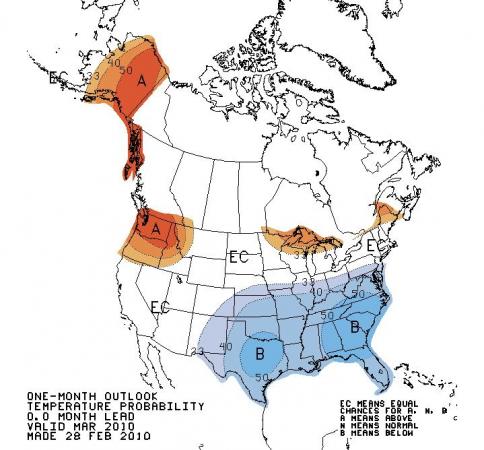
Some computer models indicate El Nino should weaken through the next few months and perhaps revert to a neutral condition around June or July, and it tends to have reduced influence here as we move into the warmer months anyway, but at least into early Spring we may continue to average a little cooler than normal across the southeastern U.S., as indicated on the attached March temperature outlook from the Climate Prediction Center. At least the next week or so looks to run near or above normal, though, a nice break from the chill!
Copyright 2024 by Capitol Broadcasting Company. All rights reserved. This material may not be published, broadcast, rewritten or redistributed.


 for 2024 season")


