
The snow storm that blanketed a good portion of North Carolina at the beginning of the Valentine's weekend was a little unusual in that we didn't have to deal with lots of transitions from rain to snow to sleet and so on, either geographically or over time. While temperatures hovered close to the freezing mark right at the ground early in the event, they rapidly decreased to colder values aloft, leaving us with all snow just about statewide, and we also saw, due to a rather southerly low pressure track, the heaviest accumulations across parts of the coastal plain and south-central coast, where 5-8 inches was reported.
Around the Triangle, amounts ranged from about 2-4 inches in general, but you may have noticed that once the snow was over a lot of it went away in a hurry compared to last big event at the end of January. A big part of the reason was warmer temperatures near the surface during and after the snow, and the icy, hardened character of the earlier snow/sleet mix.
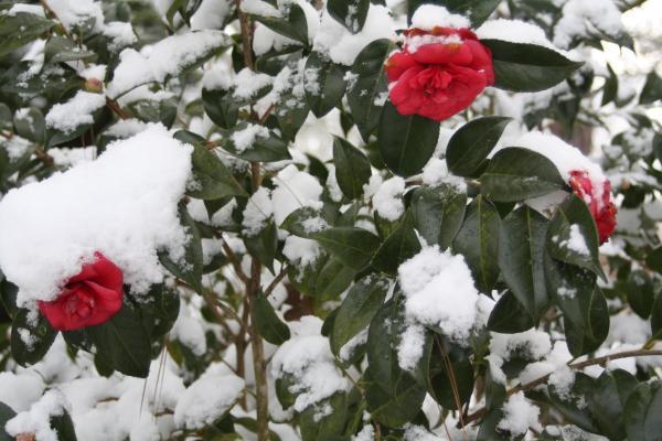
Another important factor, though, was how much actual moisture was involved in producing the white coating that we had at the end of each storm. You may have noticed that this past Saturday's snow was "sticky" enough to cling onto trees and bushes and the like, but it was also quite light and fluffy in comparison to the final result of the previous storm, in which periods of sleet left most of the trees and bushes bare but gave a more dense consistency to the mix on the ground. We're able to put some numbers on these differences by checking the ratio of snow to the amount of liquid water that the snow (or snow and sleet) melts down to.
That ratio can be highly variable from storm to storm and even over time during a single storm, and it can also be tricky to measure with great precision and confidence. Some of the factors that affect the ratio are the temperature and humidity profile at the levels where snow crystals initially grow, the profile of temperature and humidity below that layer as the crystals and larger flakes (which are aggregates of multiple crystals stuck together), the shapes of the snow crystals, and how windy it is (wind can break up nicely formed crystals as they fall or when they strike the ground, lowering the amount of air trapped between them and therefore how deeply the same amount of flakes or crystals pile up over time).
In our area, a good general average for the ratio of snow to liquid is about 10 inches of snow from an inch of liquid water, or 10:1. However, this is only an average and a wet, heavy snow or one with a few periods of sleet and freezing rain mixed in can run closer to 5:1, while a very cold, fairly dry snow with optimal conditions for growing nice crystals, having some of them stick together, and then falling through fairly light winds might reach a 25:1 ratio.
To give you a sense of the last couple of sizable storms here, these are the numbers from the Raleigh-Durham airport: back on 29-30 January, the total snow accumulation there was 5 inches, with a total liquid water equivalent of .71 inches, for an overall ratio of about 7:1. As you can see, the sleet kept our ratios on the low side of that 10:1 average I mentioned, and in fact the ratio went down steeply as sleet mixed with the snow. In that event, the ratio was about 14:1 on Friday evening, but for the part of the storm that occurred after midnight, it was only 6:1. More recently, on Friday evening, Feb 12, one inch of snow fell at the airport, with that amount equating to .1 inch of liquid for a 10:1 ratio, while the snow that fell after midnight added up to another inch accumulation as temperatures cooled a little more, but with only .05 inch water, for a 20:1 ratio. That left the entire event with about a 13:1 ratio. A good comparison of the two events, then, shows that while we had 2.5 times as much snow at the airport in late January as with 12-13 Feb system, there was about 4.7 times as much water involved!
In checking several other stations around the area, the most common range seemed to be about 12:1 to 18:1, meaning that when it was time for the sun to shine and the snow to melt and/or evaporate, there wasn't all that much left to get rid of, and a lot of us had dry roads by Saturday night.
For a list of snowfall reports around central NC from the most recent event, see the link I attached...
Copyright 2024 by Capitol Broadcasting Company. All rights reserved. This material may not be published, broadcast, rewritten or redistributed.


