Stormy Saturday
For most of this week, we've been eyeing the pattern for Saturday has holding the potential for some severe weather across the area. As we've gotten closer, our concern has only grown. As of this morning, I'm concerned for not one, but two rounds of potentially rough weather on Saturday
Posted — Updated
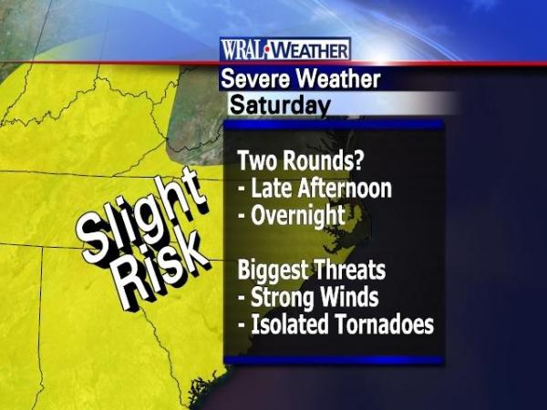
As of this afternoon, I'm concerned for not one, but two rounds of potentially rough weather on Saturday:
- The first would happen during the afternoon, where we could see thunderstorms develop in the warm, humid air mass ahead of tomorrow night's cold front. How strong these storms get will depend largely on how unstable the atmosphere will get. If the sun is able to break through the clouds, we'll see the sun's energy heating up the lower levels of the atmosphere, making things more unstable. The more sunshine we see on Saturday morning and early afternoon, the more likely it is that we will see storms and that some of those storms will be strong or severe. The biggest threats will be for strong, damaging wind gusts and, unfortunately, some isolated tornadoes.
- The second round would come later Saturday evening into Saturday overnight, when a cold front will march across the state. The storms here would likely gel into a squall line, producing straight-line wind gusts along with very heavy rainfall. It's not out of the question that we could see a tornado overnight Saturday, but the setup will favor a squall line over tornado-producing storms.
You can also follow the storms here on WRAL.com:
- Track storms using DUALDoppler5000 and our iControl Interactive Doppler tool.
- See a funnel cloud, large hail, or storm damage? ReportIt! We may use your pictures or video on the air or on WRAL.com.
- New to the area? Learn more about our severe storms and how to stay safe on our special Severe Weather Awareness section.
- Away from your computer? Keep up with the weather using WRAL Mobile.
You can also follow and interact with us on Twitter! Take a look at some of our latest Tweets:
Bottom line: You can count on WRAL — on the air, on the web, and on your mobile phone — to track the storms and help you stay safe.


Copyright 2024 by Capitol Broadcasting Company. All rights reserved. This material may not be published, broadcast, rewritten or redistributed.


