Turning Much Cooler Late Next Week?
Could we be looking at our first true shot of autumnal weather? Some medium-range forecasting guidance is pointing to a very emphatic "yes". Brandon Locklear, a forecaster at the National Weather Service office in Raleigh said, "There is remarkable agreement among medium range models and ensembles alike indicating a sharp turn to a strongly positive PNA pattern... which supports a deep trough over the eastern US. ... This pattern is [forecast] to hold through nearly the first half of October. It should be interesting to see if this does indeed hold up and if we will need to break out those sweaters." So, what is this PNA he's talking about, and why does a positive PNA pattern mean below normal temperatures for us?
Posted — Updated
Could we be looking at our first true shot of autumnal weather? Some medium-range forecasting guidance is pointing to a very emphatic "yes".
Brandon Locklear, a forecaster at the National Weather Service office in Raleigh (and a fellow Wolfpack alum) recently said in a note passed along to other forecasters in the area:
There is remarkable agreement among medium range models and ensembles alike indicating a sharp turn to a strongly positive PNA pattern... which supports a deep trough over the eastern US. ... This pattern is [forecast] to hold through nearly the first half of October. It should be interesting to see if this does indeed hold up and if we will need to break out those sweaters.
IT'S ALL ABOUT YOUR CONNECTIONS
Before we can talk about the PNA specifically, we need to step back and discuss teleconnections in general. Teleconnections, or teleconnection patterns, are large-scale (e.g. continental to hemispheric) setups of the winds and other parameters in the mid- and upper-levels of the atmosphere. Properly identified or forecast, teleconnections can give us good information about what the atmosphere is set up to do on a broad scale. They're not fool-proof, but they can be a valuable tool for at least getting an idea about the forecast "beyond the 7-day."
In a nutshell, teleconnections are all about connecting an event or events in one place to events in other places far away. If you remember that "tele" comes from the Greek word for "far away", you can see how we get the word, "teleconnections."
One way to look at teleconnections is to think about rush hour traffic patterns around the Triangle.
On a normal day -- no construction, accidents, etc. -- there are places where traffic always flows smoothly, and other places where it can get jammed up a bit. For example, I-540 tends to flow pretty well most of the time, I-40 west from Gorman Street on past Airport Boulevard gets slow, and the US-1/I-40 interchange near Cary can be pretty foul at times, too.
Now, let's assume the DOT wants to close a lane or two of I-40 westbound from the US-1/I-40 interchange all the way to the Harrison Boulevard exit for a month. What is likely to happen is pretty predictable: Morning traffic will start backing up on I-40 west long before Gorman Street, and we'll also see a deeper backup on northbound US-1 as traffic tries to get onto I-40. That may also result in backups on Wade Avenue and the Outer Beltline as a result of people trying to find their way around the lane closures.
In other words, something happening in one place -- I-40 from US-1 to Wade Avenue -- will have effects on the pattern of traffic in far other places. Now, there may be days in that month where the backups are better or worse than others, but on the average, if you told me "construction on west-bound 40", I'd say "delays here, and here, and here."
That, my friends, is a teleconnection.
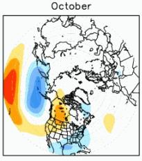
The "PNA" Locklear mentioned above is short for the "Pacific/North American teleconnection pattern." It describes the overall setup of large-scale features (ridges and troughs in the upper level "jet stream" winds, for example). If you've watched Greg much, you know that these deviations in the path of the jet stream and the features that cause them can have consequences for our weather here.
For example, when a "ridge" sets up over us, that typically spells a quiet weather forecast with at- or above-normal temperatures. On the other hand, when a "trough" is in place, that usually brings northerly winds above us, opening the door for colder air to move in from colder places, such as Canada.
And that's exactly what the PNA forecast means for us. Specifically, the "strongly positive PNA" forecast means that the jet stream will likely set up farther north in the eastern Pacific through the western United States than it usually does. The jet stream will then plunge farther southward than normal, carving out a trough over the east coast. That should mean, on the average, cooler temperatures than normal for the time period from late this week through, as Locklear says, mid-October.
THE BOTTOM LINE
If this forecast for a strongly positive PNA pattern is correct, we can expect cooler than normal temperatures starting late this week and lasting through the following week or two. Since the normal temperatures for early October are highs in the mid-to-upper 70s and lows in lower 50s, that would mean we could see some days with highs in the lower 60s (if not 50s?) and perhaps some overnight lows dipping into the upper 30s and lower 40s. Just with our example above, this doesn't mean the entire time will be that cold, but it opens the possibility.
In any event -- and for what it's worth -- when I put together my 7-day forecast this morning, my forecast low temperature for next Friday morning was 49°F. I can't wait!
Copyright 2024 by Capitol Broadcasting Company. All rights reserved. This material may not be published, broadcast, rewritten or redistributed.


