
As the old saying goes, with more than one watch, you may have a hard time being sure what time it is. Something along those lines can happen in weather forecasting, as well as in other disciplines involving an attempt to model future behavior of complex systems, and while it can sometimes be a source of frustration and uncertainty regarding the most likely course of events, it can also at least provide a sense of how much confidence to place in the forecast for a particular time frame.
The figurative "watches" in this instance are different computer forecast models, and the "time" is the weather pattern that results from each model at various points in the future. When the resulting patterns are in close agreement among several different models, or from several different runs of a single model with "perturbations" of the observed data fed into it (these are meant to simulate the kinds of errors and uncertainties inherent in measuring the atmosphere with imperfect instruments, and the fact that there are large spatial gaps between the measurements that are made so that temperature, pressure, winds, etc in those spaces have to be inferred), one can have reasonably high confidence that the forecast patterns will verify as pretty accurate. When there is an especially large span of differing solutions, that level of confidence can be considerably lower.
One example of that you're probably familiar with are the "spaghetti" tracks we sometimes show on the air that have the calculated paths of a tropical cyclone center as computed by several different models. Sometimes the paths all group together quite nicely, and the eventual path of the storm often falls right along that envelope. Other times, they may spray out in several different directions at several speeds and it is tougher to know quite where the real track will be. In the case of the recently downgraded Tropical Storm Fay, there was a short time early in its life cycle where tracks were in fairly poor agreement and several models, along with the official hurricane center forecast, brought it right up the eastern seaboard. However, before the storm ever made its first of four (!) landfalls in Florida, the models began doing a surprisingly good job with picking up on the zigzag path that was to eventually develop.
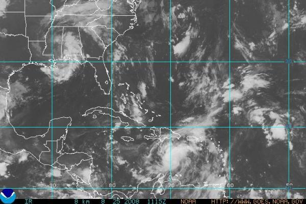
All those models may have another depression or named storm to deal with in the next day or so, as there is a tropical wave in the lower Caribbean (just north of South America and south of Hispaniola in the attached NOAA satellite image) that appears poised for further development. So far forecasts for the next few days split into two camps, the dominant one a northwest track just south of Cuba, the other (less favored) turning more to the north across the Dominican Republic and moving north across the western Atlantic. It's a tricky call, as there is a second tropical wave up in that area that some models intensify while weakening or dissipating the one I pointed out here, or even merge the two.
Just as an indication of how different the eventual results can be, I posted three images from the tropical models page of the Penn State E-Wall site, with the surface pressure pattern for 8 pm Sunday evening Aug 31st. The first is the U.S. Global Forecast System (GFS) model, the second from the European Center for Medium Range Weather Forecasting (ECMWF) , and the third from the Canadian Meteorological Center (CMC). A quick scan shows that there is plenty of uncertainty for the southeastern U.S. forecast for late in the weekend. For now, we are leaning closest to the GFS model for our local forecast, but it is with fairly low confidence. The image here shows weak high pressure over the Great Lakes, a weak low over the far southeast, evidence of a modest cold front stretching from eastern Canada into North Carolina that would bring some potential for widely scattered thunderstorms, and the poorly developed extrapolation of one of the tropical lows I discussed above over the Atlantic several hundred miles east of the GA/SC border. The ECMWF model (image 3 above) has a very different solution with a much stronger tropical cyclone a little northeast of the GFS position, and a MUCH larger high pressure center extending out of eastern Canada and down the eastern seaboard of the U.S., a pattern that would imply dry weather and a good chance at bright skies around here.
Just to throw another wrench in the gears, have a look at the Canadian model (4th image), which might make someone in Florida shudder just a bit. It has maintained and intensified the first tropical system we mentioned above, and by Sunday evening has it brushing the southwest coast of Florida, while a high pressure ridge with a structure somewhere between that of the other two models is extending into our state. We've noticed this particular model has a bias toward overdeveloping some tropical cyclones, and it is not uncommon for it to generate a storm like the one you see here, only to have it fail to develop in real life. The problem is, while that is a common result, it is not the case every single time, and on rare occasion this is the one model that picks up on a developing storm before most of the others. So, the odds are probably against a hurricane off the southwest Florida coast late in the weekend, but it is well worth being vigilant about for the next few days as newer observations and model results become available.
Meanwhile, the remnants of Fay, together with a frontal boundary settling in from the north, should generate some significant rain over our state during the next several days, with a general trend of higher overall amounts over western and southwestern parts of the state and lower amounts farther north and east. In spite of exceptional drought conditions over the mountains and southern foothills, it wouldn't be a surprise to have some locally serious flooding issues there between later tonight and Thursday or so.
Copyright 2024 by Capitol Broadcasting Company. All rights reserved. This material may not be published, broadcast, rewritten or redistributed.


 for 2024 season")


