
In keeping with the vaguely baseball-like theme of the title (what with local baseball star Josh Hamilton in the MLB home run derby tonight and the All-Star game tomorrow), former hurricane and current tropical storm Bertha has been "at bat" for the past week and a half almost, but there is a new disturbance that appears likely to step up to the plate as a tropical depression within the next several hours to a day or so, and model projections give it a reasonable shot at becoming our next named storm between now and midweek.
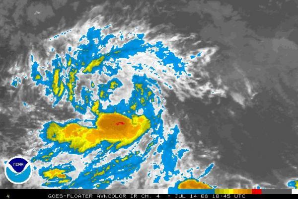
The system has become reasonably well organized, with a noticeable cyclonic swirl in satellite imagery (a still image from NOAA is attached). If a closed low level circulation is confirmed today or tomorrow it will be designated as Tropical Depression 3, and should it become the next system to develop sustained wind speeds of 39 mph or greater, it would take on the name Cristobal. It is currently located in the south-central north Atlantic, in the more or less circular potential formation area hatched in on the second attached image (from the National Hurricane Center).
The steering winds across that region are generally easterly, and projected to remain that way, so models are indicating a west to west-northwest track for several days, with the Global Forecast System, for example, indicating the storm may cross the central Antilles sometime on Friday as shown on the third image, taken from the Penn State tropical "e-wall" site. This particular model does not indicate all that much intensification (compare the circulation around Bertha to that around the newer storm in the upper right-hand panel of the image), but large-scale models are often slow to "catch up" to intensity changes, so we'll have to give it a day or two to see how this one is progressing. Most models cluster along a fairly similar track, with some a little faster or slower, and some a little farther north (more toward Puerto Rico by week's end, for example).
In the meantime, Bertha has had some effect on our coast, in the form of long wavelength swells that have brought a significant rip current risk for the past few days. It also appears likely to produce tropical storm force winds and heavy rains on Bermuda for the next day or two before drifting away toward the east.
Otherwise, our weather will be dominated today by a passing "cold" front that should assist with formation of some hit and miss showers and storms (some places mostly missing out on rain, a few receiving heavy downpours), to be followed by an intrusion of drier air from the west tonight and tomorrow. By Wednesday and Thursday, we'll likely see mostly sunny skies and another significant reduction in humidity, before the outlook becomes a little more unsettled again for the weekend. In the meantime, the front crossing the region today will slip offshore to our southeast and dissipate. This time of year and again in the Fall, those decaying fronts can sometimes serve as breeding grounds for new tropical systems - while there's currently no strong indication that will happen, it will be an area to pay attention to just in case.
Copyright 2024 by Capitol Broadcasting Company. All rights reserved. This material may not be published, broadcast, rewritten or redistributed.


