
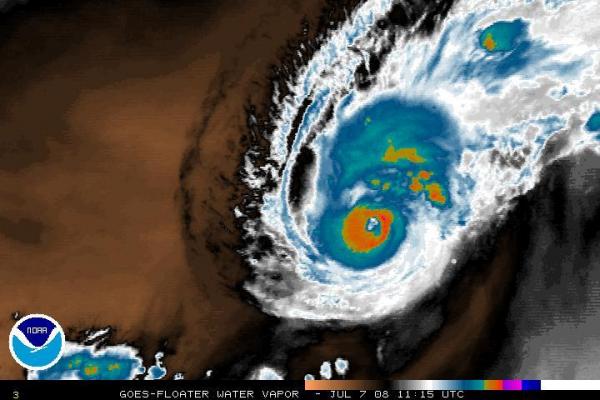
After several days tracking over relatively cool ocean waters in the far eastern Atlantic, former Tropical Storm Bertha was upgraded to hurricane status early this morning with estimated maximum sustained winds of 75 mph. The storm has become a little better organized and intensified a bit as it has tracked over gradually warmer water, adding heat energy and buoyancy to the system. The intensification has been fairly gradual, and may be limited a bit by some modest southwesterly wind shear across the storm, in addition to some rather dry ambient air in the mid-levels of the atmosphere to the west and southwest of the storm. All of that is a little evident in the attached water vapor satellite image from the National Hurricane Center, where the orange-brown colors indicate fairly deep dry air, and the cirrus cloud stretching away from the storm toward the northeast indicates a bit of shear in that direction. Nonetheless, Bertha has gained enough intensity and organization to begin to form a recognizable eye, as seen in the second satellite image, this one taken in the visible spectrum (like a photo from space) with its higher resolution.
The third image is a track map from the Unisys tropical web site showing the past and projected track of the storm, indicating a west-northwest track for the next 2-3 days followed by a turn toward the north as we approach the weekend. Of course, after the first few days the potential location becomes more uncertain, and we shouldn't let our guard down too much regarding impacts on the eastern U.S. until we see that northward turn actually begin to set in. If it follows the current official forecast to a large degree, Bertha could be a threat to Bermuda by the weekend. For more views of the hurricane, along with track forecasts and storm preparation tips, be sure to check the "Stormtrack" section of our weather page.
An interesting bit of trivia regarding this storm is that a previous Bertha gained hurricane status on the same date (July 7th) in 1996 as this year's storm. That Bertha went on to follow a more southerly track (last image above) that brushed by just north of Puerto Rico and the Bahamas. It later recurved toward the north-northeast off the Georgia/South Carolina coast and made landfall on our southeastern coast near Wilmington as a category 2 system that then tracked across the eastern coastal plain before heading up over Chesapeake Bay and on along the northeastern Seaboard. Areas east of I-95 or so received 2-5 inches of rain from the storm, with over 7 in some places near the coast, and it ended up causing about $270 million in damages along with 12 fatalities. There was a Bertha in August 2002 as well, but that one was short-lived and never made it to hurricane strength.
Copyright 2024 by Capitol Broadcasting Company. All rights reserved. This material may not be published, broadcast, rewritten or redistributed.


