
That's how the records have been falling over the past few days as an impressive heat wave has settled upon the eastern United States, with the upper level and surface patterns such that the Carolinas and Virginia have been taking the brunt of it so far. The combination of fair skies, large-scale subsiding air, dry ground and west-souothwest low level winds sent temperatures around our area into the mid and upper 90s beginning last Wednesday, and to the century mark and beyond over the weekend. We're likely to see more of the same today and only a slight reduction in heat for Tuesday, but there is at least some hope for more typical temperatures (though still tending a bit to the warm side of normal) from this Wednesday into the weekend. In addition, sparse rainfall in the past week or so should give way to at least a somewhat better chance at isolated to widely scattered showers and storms as the week wears on, though the coverage is likely to be rather uneven on any given day.
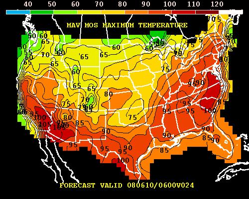
The three images above show one computer model's assessment of likely high temperatures today, Wednesday and Friday, with the first clearly showing the band of very hot readings just east of the Appalachians and also clearly marking the location of what has been a very active frontal boundary stretching from the southern plains into the Great Lakes area. This front will be edging east and southeast in the coming days, weakening and stalling over the Carolinas in the process. By Wednesday, the model is estimating highs in the upper 80s to mid 90s for our state, and mainly upper 80s by late in the week.
Regarding the records I mentioned above, here is a quick rundown of what we've dubiously "achieved" so far in this event at the Raleigh-Durham airport:
- New record highs on Friday 6 June (99, old record was 98), Saturday 7 June (100, old record was 97) and Sunday 8 June (101, previously 100).
- Warmest low temperatures on record for Wed 4 June (72, was 71), Thu 5 June (76, previously 69), Fri 6 Jun (76, was 73), Sat 7 June (74, was 71) and a tie for Sun 8 June (73).
- Earliest visit to the century mark at RDU since records began there in 1944 when we hit 100 on June 7th. That was, however, only one day earlier than the previous record, which was 100 on June 8th in 1999. It's also worth noting that another Raleigh site, one with records running back to 1890 (located on NCSU property south of town along Lake Wheeler road) managed 100 degrees on June 3rd in 1895 and 102 degrees on June 5th, 1943.
Does this all mean we're in for a long, torrid, record-setting summer? I wish there was a clear signal, but at this point the long range prediction specialists at the Climate Prediction Center aren't indicating that there is any strong indication to go on for our part of the country, and we are classed as having "equal chance" for above normal, normal or below normal temperature and precipitation for the summer months. Computer models that extend out for the next couple of weeks show a tendency toward slow cooling this week, a period of near-normal temperatures and then a broad trough across the eastern U.S. that could mean some lower than normal readings for a while - however, any computer model pattern beyond about 4-7 days has to be taken with a pretty large grain of salt, so we'll have to see how it all plays out.
We'll also have to keep an eye on the water situation, of course. A stretch of drier weather the past week or so in combination with the record heat is not an auspicious way to begin the summer having just seen some amelioration of the drought, and as of today stream flows are at very low levels across most of the state, and while ground water levels appear to be in good shape across the coastal plain, wells in the Piedmont are still showing some very depressed readings. At Chapel Hill for example, the level has risen by about 2 feet since the end of February, but remains about 3 and a half feet below the median for this time of year and within the lowest 10 percent of historical levels.
Copyright 2024 by Capitol Broadcasting Company. All rights reserved. This material may not be published, broadcast, rewritten or redistributed.


