
You say Alma, I say Arthur - and we'll all be talking about the same atmospheric circulation, one that provided both the eastern Pacific and Atlantic hurricane basins with their first tropical storms of the 2008 season, and in the process used up the "A" name for this year on both sides of Central America.
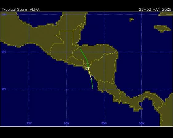
Tropical Storm Alma formed on May 29th over the eastern Pacific about 100 miles northwest of Cabo Blanco, Costa Rica. It moved north from there (see attached track map from the Unisys hurricane archive), reached a maximum intensity of 65 mph sustained winds, and quickly made landfall near Leon, Nicaragua, the first Pacific tropical cyclone on record to strike the west coast of that country (most tend to reach land farther north over western Mexico or else track to the northwest and head out into open ocean waters). Alma then weakened to a remnant circulation moving across Honduras, thus losing its name.
But not for long! As a part of the leftover circulation edged out over the Atlantic into the Gulf of Honduras, it became better organized, intensified and (while the center was actually over land in northern Belize) was named Arthur, the first name on the Atlantic basin list for this year. Arthur arced along (second map above) to the west from there across eastern Mexico just north of the Guatemalan border. It's maximum winds were about 40 mph, with those winds well separated from the center and remaining out over water, while the larger threat from the system was heavy rain over inland terrain. Arthur dissipated to a remnant circulation late Sunday evening June 1st.
It's not at all common for tropical cyclones to cross from the Atlantic to the Pacific and vice versa, but also not extremely rare. Recent examples include Hurricane Cesar becoming Pacific Hurricane Douglas in 1996, T.S. Bret becoming Pacific Hurricane Greg (I'm sure Fishel enjoyed that!) in 1993, and Pacific Hurricane Cosme, which crossed over and then struck Texas as T.S. Allison in 1989.
There's always a little bit of a judgment call on the part of the National Hurricane Center in how to proceed with these naming conventions as well. In the past , any storm that crossed from one basin to the next was automatically assigned the next name in the new basin. However, more recently the protocol was changed so that now, any named storm that remains at depression status or higher will keep its name despite the basin switch. However, if the storm dissipates to the point that only an unnamed remnant remains, and then redevelops in the other basin, it takes on the next name in that other list.
It seems unlikely that Arthur's remaining circulation will survive to reform yet again into a tropical system, but it wouldn't be entirely impossible for it to drift west into the Pacific again, or north into the Bay of Campeche, giving the Hurricane Center yet another interesting choice to make on a new (or old) name...
Copyright 2024 by Capitol Broadcasting Company. All rights reserved. This material may not be published, broadcast, rewritten or redistributed.


