
Some of you may have already seen this, but it just came to our attention a few days back. On May 8, 2008 a small outbreak of five weak (EF-0 to EF-1 intensity) and one strong (EF-2) tornadoes developed as part of a line of thunderstorms crossing northern Alabama. The strongest tornado was rated at EF-2 by a National Weather Service survey team, with a path lenth of 9.6 miles beginning around Leighton AL, a damage path width of 250 yards, and an estimated top wind speed of 125 mph.
You can see a brief survey report about the storm at the Huntsville NWS office web site, at
http://www.srh.noaa.gov/hun/stormsurveys/2008-05-08/index.php
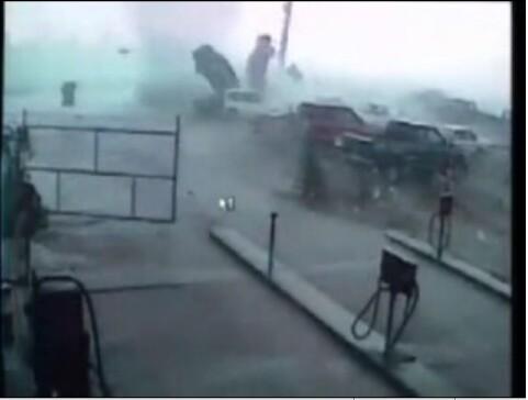
What makes this otherwise somewhat non-descript tornado stand out a bit and get a mention here is the video that was captured by an equipment company surveillance camera. The sequence is widely available on the internet, one example being at
http://www.youtube.com/watch?v=ecDq7lPwufc
This a striking example of how rapidly some tornadoes can move along their forward path, how suddenly winds can rise from breezy to damaging and then subside again, how even a low-end strong tornado can toss automobiles around like toys (imagine the scene in a large EF-3 or stronger storm), and how capriciously focused or channeled the most intense winds can be (notice how several cars that are only a few yards from the others barely moved). Fortunately, this tornado apparently did not cause any injuries or deaths.
Nonetheless, it provides a strong visual reminder as to why most tornado safety experts recommend that people not attempt to ride out tornadoes inside cars, and recommend instead that if caught in the path of a tornado in a car without an obvious escape route (such as open road in a direction more or less perpendicular to the tornado's path) it is better to leave the car and attempt to find a ditch, culvert or other terrain depression in which to lie face down and cover your head.
Unfortunately, we had a tragic example of that danger realized not so far west in the Triad later on the same day as the Alabama storms, when one person was killed and two were injured, all in vehicles, by a tornado that reached EF-3 intensity in the Sandy Ridge-Greensboro area. Prior to those occurences, while the system was apparently at EF-1 strength, the tornado also overturned several other vehicles as it crossed Interstate 40. You can read more details and see storm paths and photos at
http://www4.ncsu.edu/~nwsfo/storage/cases/20080508/
Copyright 2024 by Capitol Broadcasting Company. All rights reserved. This material may not be published, broadcast, rewritten or redistributed.


