
Maybe someone around here hasn't been sending "Mother Nature" her card in a timely fashion! Twice in the past three years, the holiday for Mom has been marked by a notable outbreak of severe thunderstorms that included North Carolina, and the overall weather patten involved was remarkably similar, with a frontal boundary more or less stalled over the region, a large contrast in temperature from northwestern parts of the state to the southeast (yesterday's high in Greensboro was 63, while Fayetteville reached 80), a strong mid-upper level jet streak impinging from the west and southwest, an upper level trough approaching from the west, and a surface wave of low pressure forming over western parts of the state and tracking northeast.
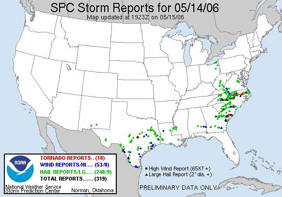
In both cases, the result was numerous reports of large hail, strong wind gusts and several confirmed tornadoes. One difference was the particular distribution of those storm impacts. This year, a line or two of intense storms that tracked across the state weakened a bit as they moved across the western Piedmont, produced relatively sparse severe weather impacts across central Carolina, and then became re-energized over eastern parts of the state. Looking farther afield, the earlier event also included an outbreak of severe weather across Texas that did not occur this year, and vice versa for a cluster of high wind reports over eastern Kentucky. For a look at how the two holidays stacked up, see the attached images. The first is from 2006, and shows quite a few hail, wind and tornado reports along something of a broad corridor from southwest to northeast in our state, with notable gaps over the southeast coastal plain and southern mountains. This year, the most widely spared area was the Sandhills, eastern Piedmont and western coastal plain.
Both events included locally significant damage, in addition to some especially eye-catching hail reports. It is quite rare for storms in our state to produce hail exceeding about two inches in diameter, but yesterday hail reaching tennis ball to baseball size (2.50 to 2.75 inches) was reported in Lincoln and Cabarrus counties in the southwest Piedmont, and reports from Bertie county in the northern coastal plain included both a tornado that resulted in two injuries, and hail described as grapefriut or softball sized, or about 4.0-4.5 inches.
For a detailed overview of the 2006 Mother's Day storm, see the report at
http://www4.ncsu.edu/~nwsfo/storage/cases/20060514/
I suspect a report on "Mother's Day, the Sequel" will be posted there soon...
Copyright 2024 by Capitol Broadcasting Company. All rights reserved. This material may not be published, broadcast, rewritten or redistributed.


