
We've had a pretty active period of weather through the past three days across North Carolina, as a cold front and deepening upper level trough made an approach to the state from the west. For some time prior to the event, we had mentioned some potential for strong or severe thunderstorms on Monday. As it turned out, the combination of instability and vertical wind shear was such that severe weather was limited over much of our viewing area (one report of trees and power lines down just outside the "official" viewing area in the Halifax county, VA town of Virgilina), with locally heavy downpours and a decent amount of rainfall in general being the bigger issues. However, on a more regional basis, severe storms were observed, and we ended up seeing several tornadoes produced not too far north and east of us.
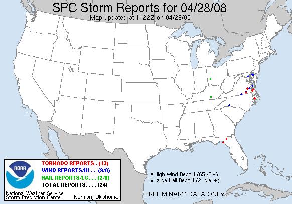
In North Carolina, tornadoes were indicated on radar and sighted just east of Belhaven in Beaufort county and across the Pungo River in Hyde county (see the red dot on the national severe reports map from the Storm Prediction Center, and the cell on the radar image that is located about 45 miles northeast of the radar site). Based on a radar loop during the time these reports were collected, they may well refer to the same twister moving east-northeast out of eastern Beaufort and into western Hyde, though it is also possible the same cell could have generated multiple short-lived, weak vortices. Fortunately, no damage was reported from this storm.
The same could not be said for some of the tornadoes over eastern Virginia, with the Suffolk area in particular seeing some notable damage. A few people in that area caught one or more of the funnels on video, and you can find some of them on YouTube already, one example being
http://youtube.com/watch?v=w32d-JYpc7g
The rest of our work week looks a lot more tranquil, as an upper level trough rotates away to the northeast. In it's immediate wake, we'll have a couple of days with temperatures about 5-10 degrees below normal, followed by a rapid warmup Thursday and Friday as an upper level ridge builds into eastern parts of the country. The weekend outlook remains a little uncertain, with some significant differences amongst the major computer models. All are in reasonable agreement that we should see a few more clouds and potentially a shower or storm on Saturday. While the ECMWF (European) model, however, slows a front down over us with a continued chance of storms on Sunday, the GFS (U.S.) and CMC (Canadian) models both move the moisture and lift along to to our east more rapidly, for a generally bright and dry finish to the weekend.
Copyright 2024 by Capitol Broadcasting Company. All rights reserved. This material may not be published, broadcast, rewritten or redistributed.


