
We had an Easter weekend across central NC that featured a mostly dry cold front that split up Saturday and Sunday between "comfortably warm" and "pleasantly cool," as the RDU airport topped out at 75 degrees Saturday, thanks to a combination of sunshine and gusty southwest winds. By Sunday, though, a fairly strong cold front had crossed the area, and while we saw bright skies once again, much cooler air was flowing in from the north, giving us a high that was 17 degrees cooler at 58. The front that moved through was a dry one for most of us, though it did trigger a few widely scattered showers over eastern Virginia and the eastern Coastal Plain of our state.
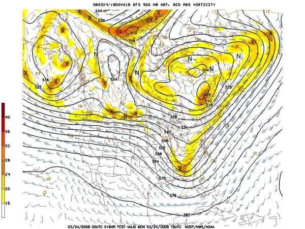
Later on, we saw a trailing system in the upper atmosphere move into the region last night in the form of a deepening trough. The attached image shows the projected position of the trough early this afternoon. This system was pushing in over top of a sprawling high pressure area at the surface, and with northerly winds in place through the lower atmosphere there wasn't much deep moisture available for that system to act on. That remains the case today and as a result, while the upper trough and some very cold air aloft that will move in with it does have just enough moisture to generate some cloud cover and light, spotty precipitation, it appears unlikely any of us will see more than a few hundredths to a tenth of an inch of rain before it moves east of us this evening and clearing ensues. We did have just enough cold air in place for a few patches of light snow with the system this morning, but the light nature of the precipitation, along with air temperatures above freezing and soil temperatures around 50 degrees, meant that there wasn't much of a concern for wintry problems, just a taste of winter in the form of a few wet snowflakes for folks in the right place at the right time. This system isn't of much help with the drought, and for now it appears we may have a pretty dry stretch ahead for the next several days, before a chance at some showers on Saturday and at least a shot at an unsettled period early next week.
You might wonder how late in the year we've had snow around here. On occasion, it has stretched well into the spring. Climate stations around Raleigh have reported measurable snow as late as April 18th (1.8 inches fell that day in 1983) and a trace of snow as late as May 2nd, which happened in 1939. However, as we head out of March and into April next week, we're moving from a month in which we historically have about a 29% chance of getting some measurable snow (about once in every three to four years) to one in which that chance falls to a little under 4%, or about once in every 28 years.
If you're interested in hunting up statistics like that for other parts of the state or the country, the National Climatic Data Center has a nice "snow climatology" page located at
http://www.ncdc.noaa.gov/ussc/index.jsp
Copyright 2024 by Capitol Broadcasting Company. All rights reserved. This material may not be published, broadcast, rewritten or redistributed.


