
An assortment of brief topics in today's blog...
First, a weekend wrap-up as we had a shallow but intense upper level wave and surface low pressure center cross the region on Saturday. The system was quite productive in terms of rain with most of the area receiving somewhere between one quarter inch and one and a half inches, with a large number of readings in the .7-.9 inch range. A few of the totals included .82" at the Raleigh-Durham airport, .65" at Rocky Mt-Wilson, .95" at Fayetteville and 1.3" around Angier. For RDU, this leaves us with about 8.5 inches for 2008 so far, which is 1.2 inches below normal. However, for the month of March so far we're about 1.8 inches above normal, certainly a positive trend if it can be continued. The lower end of the scale for this weekend's rains were north and west of the Triangle, with about 3-8 tenths of an inch on average. As of Monday morning, this had only resulted in about a 5-inch rise in the Falls Lake level (to 249.22 feet), though some additional runoff could continue for another day or two.
There were some severe weather reports with the system that crossed the region this weekend, mostly in the form of large hail and strong downburst winds, with most of those reported over the southern third or so of our viewing area. Of course, the storms proved even more intense a bit farther south, with numerous tornadoes reported across northern Georgia and South Carolina, along with two in the southeastern corner of our state. One of those was in Columbus County near Fair Bluff, the other in the Pender County town of Hampstead. In addition, thunderstorm downburst winds resulted in damaged homes and minor injuries to seven people in a mobile home park near Rocky Point, also in Pender County.
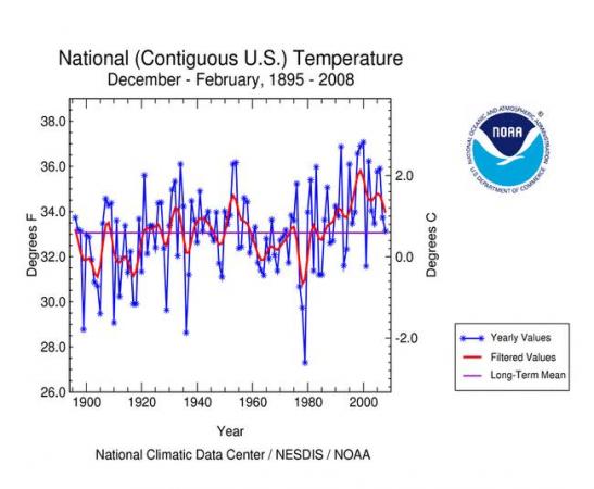
NOAA issued an interesting news release this week, reporting average winter temperatures for the contiguous U.S. (first graph above) that were the coolest since 2001, possibly linked to a moderate to strong La Nina pattern that also contributed to the coolest global average land and sea surface temperatures (second graph) since that same previous La Nina year. For the U.S., that led to a middle-of-the-pack winter that was the 53rd coldest on record out of 113 years of data. Globally, the impact wasn't quite as strong, as the global winter was the 16th warmest on record. There was a significant jump in northern hemisphere winter snow cover for the season, which on average was the greatest since winter 2003-04. An especially snowy winter in China helped contribute to this, thanks in part to a blocking pattern noted by NOAA, which featured persistent high pressure over eastern Europe and some warmer-than-normal water temperatures in the China sea that produced both a favorable storm track and especially large amounts of moisture feeding into those storms. It was noted that the overall pattern reversed during February, and by the end of that month snow cover for the northern hemisphere was below normal for the date. For more details on all these winter climate observations, see http://www.ncdc.noaa.gov/oa/climate/research/2008/feb/feb08.html.
Finally, back on a more short-term and local note, we're seeing a quiet and cool start to the week for St Patrick's Day, but appear to be in for another band or two of showers and possibly strong storms later Wednesday or Wednesday night as a cold front and upper level trough approach from the west. It's still early to have confidence in rainfall numbers, but models are suggesting around one to three quarters of an inch at this time. In addition, we may be in for another blustery day on Wednesday as a strong pressure gradient develops between a low to our northwest and a high center to our southeast - again, a little early for specifics, but some warm southerly wind gusts above 40 mph would appear to be possible - stay tuned!
Copyright 2024 by Capitol Broadcasting Company. All rights reserved. This material may not be published, broadcast, rewritten or redistributed.


