
Kind of a weak take-off on the old dog food name for a post title, but the idea comes from the kind of relatively shallow, fast-moving, and low-intensity upper level disturbances (low pressure waves aloft) that have been passing across the region over the last several days. While these disturbances are not especially strong and therefore don't tend to send our temperatures soaring to record highs or crashing to record lows, they do result in rapid fluctuations over the course of a day or two at a time, along with rapid variations between mostly cloudy and mosty sunny skies and fairly frequent, though relatively light, periods of precipitation.
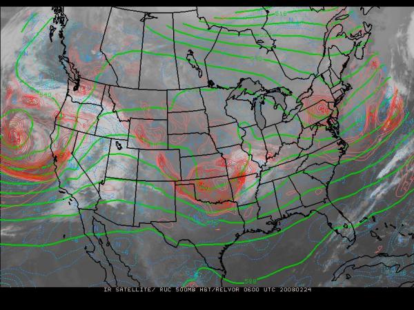
A satellite image from this weekend (available from the "electronic map wall" at Penn State University) illustrates the pattern nicely, with the picture from 1 am Sunday morning showing a disturbance that affected our area last Thursday into Friday moving out of the image into the Atlantic, a second disturbance moving into the middle Mississippi Valley (this one zipped across our state last night and produced some sprinkles and light showers, but only enough to leave behind a few hundredths of an inch of rain for most of us) and a third system, potentially a little stronger than the others, advancing onto the west coast out of the eastern Pacific. On this image, the green lines indicate the height above sea level of the 500 millibar pressure surface (this height pattern is more or less equivalent to showing a pressure map for about 18,000 feet up) while the red contours indicate the intensity of counterclockwise rotation aloft, a field called "relative vorticity." While the relationship isn't a perfect one, the areas of negative relative vorticity are often preceeded by regions of rising air, leading to formation of clouds and, given sufficient moisture, precipitation.
We've seen temperatures bouncing up and down, though not to an extreme. Friday we spent most of the day in the 30s, eventually climbing to 42 at RDU late in the evening, then popped up to 62 degrees Saturday afternoon. With the approach and passage of the next system yesterday, we saw a high of 46 degrees, and now with the third system heading in from the west for a Tuesday afternoon/evening passage, we'll again trend upward, with most of us reaching the upper 50s to low 60s today and then low or mid 60s Tuesday. The third system in the "train" looks as though it will trigger a band or two of showers and perhaps some gusty thunderstorms between late morning and mid-afternoon or so on Tuesday, before yet another surge of colder, drier air sets in late Tuesday into Wednesday, when we could see some blustery winds that gust up to around 30-40 mph. By Wednesday, we'll again see highs in the 40s, only to head back up to near 60 as we finish out the week. Our "normal" high for this week is around 56-57 degrees.
Hopefully, some of us will see some useful rainfall with the passage of the system on Tuesday - for now, computer models, together with the general pattern involved and the expected speed of the frontal passage, suggest that we should average around 2-4 tenths of an inch of rain, although with some convective cells possible, there may be some gaps with less rainthan that, in addition to a few narrow streaks with more.
Finally, if any of you happened to read last week's "To See, or Not to See" post about the total lunar eclipse, the weather turned out about as expected, with substantial cloud cover but also some helpful gaps in the clouds. At least at my house, I was able to get some nice looks at the moon leading up to and during totality, with the fast-moving cloudy patches lending a little bit of that feeling that there might be a werewolf roaming about the woods nearby - I could hear a few strains of Creedence and Warren Zevon in my head while I was out watching!
Copyright 2024 by Capitol Broadcasting Company. All rights reserved. This material may not be published, broadcast, rewritten or redistributed.


