
The title refers to the number of record highs we may tie or break over the next two days, as a deepening upper level trough to our west produces a broad southwesterly flow aloft that is likely to back more toward the south-southwest later Monday night and Tuesday. At the surface, meanwhile, we'll see a deepening low pressure system to our west along a slow-approaching cold front that should eventually cross central NC later in the day on Wednesday.
Stiffening southwesterly winds ahead of that system will make themselves felt in the form of temperatures that run even farther above normal than those we've seen in the last couple of days (our high of 66 on Sunday was 15 degrees above normal, for example) and most of us have a good chance at reaching the low or mid 70s on both Tuesday and Wednesday. Right now, we're forecasting a high of 74 Tuesday and 72 Wednesday. Of course, as we move on in time those numbers could change a bit, but it does put us in record territory. The existing record for Tuesday is 74 degrees from 1991, and we have lower hanging fruit, so to speak, for Wednesday, as the high for Feb 6th is 70 degrees from 1999. So, we have a very good chance of at least one record high this week, a reasonable shot at two, and only a small chance that unexpectedly thick cloud cover on Tuesday or a more rapid frontal approach on Wednesday would prevent either day from being as warm as forecast.
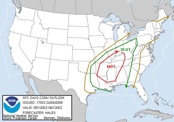
One other item to watch is the potential for severe weather with the strong upper level trough to our west and the moistening and unseasonably warm airmass ahead of it. It appears that the most favorable combination of unstable air, strong low and mid-level wind speeds and low-level turning of wind directions with increasing height will be focused across the lower and middle Mississippi Valley (from around northern Louisiana up to southern Indiana) on Tuesday, where there is a moderate risk of severe thunderstorms (wind gusts 58 mph or more, hail 3/4 inch in diameter or greater) and potentially a few significant tornadoes.
The system should lose some of it's punch before reaching our state on Wednesday as the strong upper level trough weakens and lifts by to our northwest more so than driving directly eastward across the area. However, we will have strong winds and wind shear, some limited instability, and a moderately strong cold front crossing western parts of the state during the warmest part of the day, so there is a slight risk of severe thunderstorms Wednesday afternoon or evening here as well, mainly in the form of isolated damaging wind gusts. The flip side of any band of showers and storms is the beneficial rains we could see. Right now, amounts with the system are tough to pin down, with computer models suggesting anywhere from a tenth of an inch or less on the low end to around a half inch or a bit more on the high end.
Once the front moves by, we'll see more normal temperatures for the season as we finish out the week. The record high for Thursday is 71 degrees from 1999, but by then we should be firmly in the grips of a cooler airmass, and we expect highs in the mid 50s or so despite lots of sunshine.
Copyright 2024 by Capitol Broadcasting Company. All rights reserved. This material may not be published, broadcast, rewritten or redistributed.


