
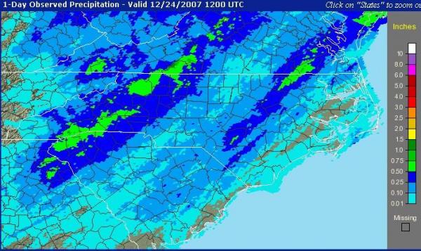
We finished out the weekend before Christmas with some welcome rain across the region, with amounts ranging from around a tenth of an inch for northwestern parts of our area to between three and six tenths along a band from around Fayetteville up through Rocky Mount and on toward Roanoke Rapids (see the image from the NWS Precipitation Analysis site). As we've seen a number of times through the current drought, though, some of the lowest rainfall totals happened to be situated over the upper Neuse river basin, and so will not help much with water supplies in most area reservoirs.
As we head through this Christmas Day, there are some forces at work that have the potential to deliver another "gift" of rainfall to the area, although the development of measurable rain appears more likely after midnight and as we head on into the morning of December 26th. The scenario that's setting up involves a fast-moving upper level disturbance that is currently crossing the lower Mississippi Valley, a stalled frontal boundary off the southeastern U.S. coast, and a surface low pressure center that will be developing along that boundary and drifting north Tuesday night and Wednesday.
We've been watching this system for a while, and to say the least it has been difficult to get a firm handle on the specifics of how fast and intense the upper system and surface low will be, as well as the particular tracks that will be taken by each portion of the overall system. Various computer models have had widely divergent solutions, and have also varied notably from one run to the next. As we've gotten closer in time to the event, they are converging more closely, but still show subtle differences that can have large impacts on where and how much rain the system produces. For now, it appears that substantial rain is a pretty good bet over the eastern Coastal Plain and probably toward the South Carolina line, and at least a possibility across the rest of our area. However, there is also a lesser chance that the surface low will track far enough east to reduce rainfall amounts a good deal west of about I-95 or so.
If the most favorable scenarios work out, we could end up with around .5 to 1.5 inches of rain over much of the area, and maybe a little more in spots. A less favorable combination should still produce measurable rain for most of us, but amounts may be limited to a couple of tenths or less for those of us in the Piedmont and Sandhills.
Luckily, it does appear that more unsettled weather is in the cards toward the weekend - details remain elusive and subject to change, but the patterns setting up for the period indicate at least some chance of rain for Friday and Saturday, and perhaps our best shot at some significant rainfall on Sunday.
In the meantime, all of us here at the WeatherCenter send out our warmest wishes to everyone for a happy and healthy holiday season, and a great '08!
Copyright 2024 by Capitol Broadcasting Company. All rights reserved. This material may not be published, broadcast, rewritten or redistributed.


