Rain, and Then Some!
About 4.7 inches fell at the RDU airport, and unlike some earlier brushes with rainfall, in which amounts were very much lacking over the upper portions of local lake and reservoir watersheds, this time we saw around 3.5 to 4.5 inches on average across those areas.
Posted — Updated
A week or so ago we were still in the process of trying to nail down a difficult forecast that involved a developing cut-off low pressure system aloft to our west. By Monday, we were already indicating a chance for rain Wednesday through Friday, but how widespread the activity would be and how intense the rain rates would become were still very much open to question, because of the difficulty in predicting the movement (if any) and intensity of the cut-off low.
Given the exceptional drought gripping the area, the eventual positioning of the upper low, and how it interacted with a surface high to our north and a wide band of deep moisture that fed in from the south, could not have turned out much better for the area. From Wednesday into Saturday, bands and clusters of shower and sometimes thunderstorm activity swept into and across our state, and although on any given day parts of the area missed out somewhat, the repeated nature of the showers over a three to four day period ended up filling in nicely for good coverage over most of the region. This is especially true if you also take account of some patchy rain that fell about one week earlier. From a personal standpoint, the rain gauge at my home just off Holly Springs Road south of Raleigh saw just under one half inch from the earlier round of rain, and then last week was inundated with 4.7 more inches, the bulk of that falling on Wednesday and Friday.
Over the same period of time, about 4.7 inches fell at the RDU airport, and unlike some earlier brushes with rainfall in which amounts were very much lacking over the upper portions of local lake and reservoir watersheds, this time we saw around 3.5 to 4.5 inches on average across those areas, with even higher peaks of around 5-7 inches for the headwaters and source areas that feed into Kerr and Jordan Lakes in particular. This has translated into some nice rises in the level of some lakes, although it is difficult to correlate specific lake rises with particular rainfall amounts because of the effects of rain intensity, antecendent soil conditions, how rain is distributed around the watersheds, how water flowing into and out of the lakes is regulated by the Corps of Engineers, and local water demands. Nonetheless, as of early Monday morning, we've seen Falls Lake rise about seven tenths of a foot since last week's rains, while Jordan Lake has come up by about 2.1 feet and Kerr Lake has risen about 2.5 feet.
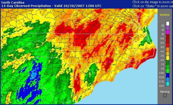
I've included two graphics here, the first a rainfall estimate from the NWS National Precipitation Analysis site covering the past 14 days and therefore the last two major precipitation producing systems to affect the state. Almost all of central and eastern NC got at least two inches during that time, and you'll see many areas within the red and orange contours, indicating 4-6 inches of rain. Of course, it is worth noting that these contours are based on a combination of radar estimates and scattered surface rain gauges, so that the rainfall amounts are "smoothed" a bit, and that rainfall can vary significantly on a highly localized basis with the passage of small but intense convective cells. The second graph is a Haw River level at Jordan Lake, which matches the lake level and gives a good sense of how the lake level has responded to the recent enhancement in inflows.
Unfortunately, prospects for more significant rain this week appear limited, with a fairly zonal (flat east-west) flow aloft that appears it will be lacking in moisture and lift needed to produce rain. There area a couple of interesting wrinkles in a few of the models that, if they turn out to be accurate, could result in some rain around late Wednesday or Thursday, especially toward the coast, but for the moment these are outlier solutions and most of our viewing area has a greater chance of staying dry. We'll also keep an eye onTropical Storm Noel, of course, in case it follows a track closer to the coast than currently indicated by the National Hurricane Center.
Finally, high pressure that built in from the northwest last evening has cleared our skies and ushered in a cool and dry airmass. We already dipped into the upper 30s this morning, and it appears dry air, clear skies and diminishing winds will allow for even colder readings Tuesday morning, which may begin with frost for a lot of us, even as most reported air temperatures should remain a little above freezing. As a result, the NWS has placed most of the area under a Frost Advisory for later tonight.
Copyright 2024 by Capitol Broadcasting Company. All rights reserved. This material may not be published, broadcast, rewritten or redistributed.


 for 2024 season")


