
... and the reason is it feels more like Summer than Fall despite how far we've advanced into October already. We closed out the weekend with a high of 90 degrees at the Raleigh-Durham airport, the 81st day this year to reach that level. That in itself did not represent a record, because we had reached 93 degrees on October 7th back in 1951. However, record highs for RDU today and tomorrow are 87 and 88, respectively, and we would appear to have a very good chance to exceed 90 degrees both days, courtesy of a very warm ridge of high pressure at the surface and aloft that has allowed heat to build across the central and eastern parts of the U.S. for the past several days. If our forecasts of 90+ readings prove accurate for both days, our number of such days will climb to 83, exceeding the 82-day Raleigh record established at the Municipal Airport back in 1941. In addition, the 93 degree record for Oct 7th is also the latest date for any year that the temperature at RDU has reached 90 or higher, so it appears we have a good chance to extend that record a couple of days farther into the Fall.
This is a far cry, of course from the kind of weather we typically associate with the State Fair that kicks off this Friday, but the good news is that at least a temporary pattern change does appear to be in the offing for the second half of this week, as we are likely to see a pair of cold frontal passages that will ratchet our temperatures downward. The first front, Tuesday night into early Wednesday, may bring a stray shower or storm, though the chances are small, with temperatures backing off into the 80s, not so extreme anymore but still well above the normal of 74. A reinforcing front should slip across the region Thursday or Thursday night, with a more noticeable turn to seasonably mild weather, and probably some blustery northwest winds, in the wake of that. The result should be a breezy and fairly bright start to the State Fair on Friday, with highs in the low 70s or thereabouts.
As I mentioned, the fronts moving through this week appear that they will not be well supported with moisture influx ahead of their arrival, and winds aloft may have more of a westerly as opposed to south or southwesterly (and typically wetter) direction. I certainly wouldn't rule out a shower or storm in a few spots (the best chances probably overnight Tuesday into very early Wednesday) but it would appear they will be few and far between.
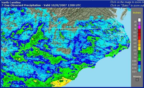
We did receive some pockets and bands of beneficial rainfall within the past week, associated with a persistent onshore flow and a trough of low pressure in the lower atmosphere to our east, and you can get a sense of how that rain was distributed from the map shown above, taken from the National Weather Service's National Precipitation Analysis page. The first green shade indicates one half inch of rain or more, and there is a large swath with those values for the Foothills and northern Mountains, as well as in the vicinity of the I-95 corridor closer to home. An anomalously heavy storm produced a lot of rain in a small area near and just to the southeast of Winston-Salem, but otherwise we again saw little rain (a few hundredths to about one quarter inch) across the upper portions of the Haw/Cape Fear and Neuse river basins, limiting the benefits in terms of watershed streamflows and water supplies for area reservoirs.
Copyright 2024 by Capitol Broadcasting Company. All rights reserved. This material may not be published, broadcast, rewritten or redistributed.


