
The title of this post, or some analogous alliteration like "tropical trifecta," makes a nice snappy subject line but certainly isn't something we can count on to develop in reality. Nonetheless, there are three disturbances out in the Atlantic Basin today that bear watching for possible development into either numbered depressions (simply meaning that an identifiable surface low pressure center and closed counterclockwise circulation form) or named storms (meaning that maximum sustained wind speeds in a depression reach or exceed 39 mph).
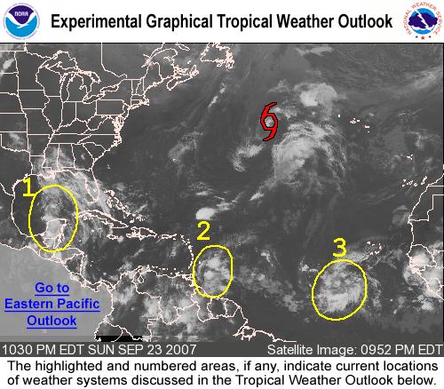
These disturbances are in addition to already active Tropical Storm Jerry, a minimal named system that is unlikely to persist as an organized tropical cyclone for more than another 24 to 36 hours before becoming extratropical and/or being absorbed into a much larger frontal low pressure system over the North Atlantic. Jerry is already north of our latitude here in North Carolina and is moving northeast far to our east, thus posing no threat to the U.S. or to our state. The other disturbances can be seen in the circled areas on the attached satellite image, which is taken from a product available at the National Hurricane Center web site. It is a graphical tropical outlook that highlights suspicious areas being tracked, provides a brief discussion on the status of each disturbance, and can be found at http://www.nhc.noaa.gov/gtwo_atl.shtml.
In the present case, we have (from left to right in the image) a disturbance that is drifting northwest near the western Yucatan Peninsula and southern Bay of Campeche. This system may encounter reduced wind shear aloft as it moves over the Gulf of Mexico in the next 2-3 days, and some computer models suggest intensification followed by a westward drift into Mexico or maybe southern Texas. The next system, just east of the Windward Islands, appears likely to take a northwestward track that could bring it up across Puerto Rico and Hispaniola after another day or two. So far, computer models are tending to keep this system fairly weak and disorganized, but that's no guarantee that some tropical development could not occur. The third system of interest is getting close to 700 miles southwest of the Cape Verde Islands in the eastern Atlantic, and may be the most likely of the three to reach hurricane status in the next few days, with upper level winds likely to become rather favorable, warm ocean waters to tap for energy from below, and most computer models maintaining or intensifying a well-organized storm. Whether one or all of these disturbances will acquire names between now and the second half of the week remains up in the air, but if they do the next three names on this year's list are Karen, Lorenzo and Melissa.
We'll also have to watch a potential low forming off the southeast coast of the U.S. around Thursday into Friday, but for now it appears that will happen just in advance of a passing upper level trough that would either steer the low off to the northeast just as it begins to deepen, or incorporate it as a non-tropical system. In either case, our rain chances across central NC don't appear too great with this system or with a frontal boundary that should cross the region later Thursday into Friday morning. We might manage a few hit and miss showers or thunderstorms with one or the other of these features, but for now the systems wouldn't seem to support anything widespread and soaking, and we'll likely transition right into a short-lived cooler and less humid pattern for the weekend, followed by another round of above normal temperatures to close out the month and kick off October.
Copyright 2024 by Capitol Broadcasting Company. All rights reserved. This material may not be published, broadcast, rewritten or redistributed.


