What was the source of Kim Deaner's showing of 3 - 4 inches of rain in her broadcast Sunday evening, Aug. 26. As a meteorologist, I checked around and couldn't find amounts that approached half that amount. My sources were the Raleigh NWS radar and the summaries from the Southeast River Forecast Center.
Posted — Updated
MIKE MOSS SAYS: Ed, While I did not see the show you are referring to, my understanding is that Kim was checking radar rainfall estimates based on Level II data from the KRAX radar site. You don't mention in your note which area she was referring to that troubles you, but there were a couple of areas in the region that stood out in terms of especially intense, slow moving cells that afternoon and evening, including the northern tier of Wayne county up into southernmost Wilson county, and another area across central and southern Robeson county.
Unfortunately, there is a dearth of rain gauge coverage across both of those regions, with the Goldsboro AWOS and ECONET sites just south of the heavy rain area, and the Lumberton ASOS site just within the northern edge of the heavy rain area observed there. The radar estimates ranged as high as 5-7 inches over the core of those two areas, and while there is not a gauge to check across northern Wayne County, it is worth noting that flash flooding was reported in Fremont, with a car stuck in a foot of water at the intersection of Sycamore and East Branch Streets there. At the Lumberton airport ASOS site, 3.56 inches of rain was reported for the event. In addition, I understood that Kim mentioned that these were radar estimates that are subject to some error, a caveat that we often add because of the uncertainties inherent in using the Z-R relationships which, while they work fairly well on average, are subject to errors due to hail contamination, bright banding, unusual drop size distributions that favor large droplets, and so on. Nonetheless, Kim contacted the National Weather Service office in Raleigh and was told that they believed the estimates were in the ballpark for these events.
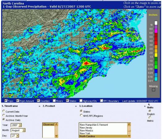
As a later follow-up, I've checked the archived 24-hour precipitation analysis map available at
http://www.srh.noaa.gov/rfcshare/precip_analysis_new.php
for the period ending at 8 am on Monday morning the 27th of August (see screen shot above). This product is derived by combining radar, rain gauge and sometimes satellite-derived precipitation estimates, with the gauge reports used in an attempt to correct any notable radar biases. This is still subject to some error, of course, but is probably about the best we can do at present. The available map for that period appears to indicate rainfall in the 3-4 inch range across northern Wayne County, with a sizable 4-5 inch peak for the Robeson County storm and also a very small 4-5 inch area over northwestern Greene county on the eastern edge of the Wayne county event. Based on your message, these are in the ballpark for the estimates Kim mentioned, although as I understand it she also may have shown a 6 inch value on one of the radar images, which could have been a high estimate that would justify a cautionary statement.
Copyright 2024 by Capitol Broadcasting Company. All rights reserved. This material may not be published, broadcast, rewritten or redistributed.


