
Maybe not... We've gotten a few messages recently about how quiet everything seems in the tropics, considering that the lack of an El Nino pattern in the Pacific, along with slightly elevated Atlantic sea surface temperatures and a couple of other positive factors led to forecasts of an Atlantic hurricane season with well-above-normal activity this year. Several groups have issued seasonal forecasts, with the range of anticipated "named storms" stretching from about 12 on the low end to 17 at the upper end. This compares to a long term average of about 10 named storms per season.
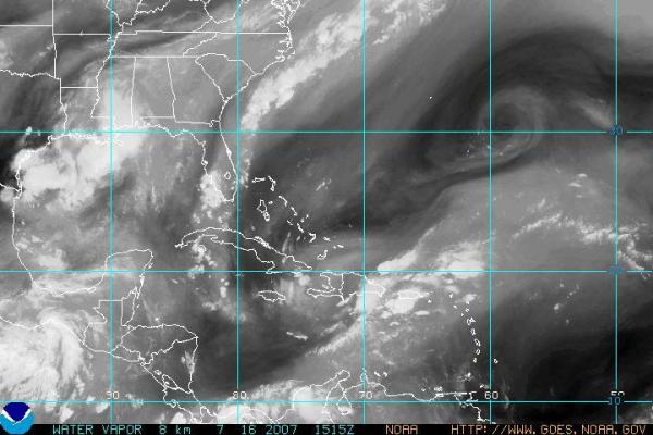
So far this year we've had two named storms, Andrea and Barry, and at the moment there are no obvious candidates for development in the next several days. The southwestern Atlantic NOAA water vapor satellite image shown above indicates a couple of areas of mid-level low pressure, one just east of Guantanamo Bay, Cuba and the other couple hundred miles east-southeast of Bermuda, but there are few surface based organized low pressure systems that seem likely to develop, although there is a suspicious looking area just south of southern Mexico in the eastern Pacific.
Of course, things can change in a hurry when it comes to tropical cyclones (and meteorology in general!) and what seems to be a fairly slow start to the season isn't really running so far behind in a historical context, as we have several prior examples that indicate how hurricane season can accelerate rapidly in terms of formation frequency, especially during the climatological maximum activity period from about mid-August to mid-October.
For a few "snap shot" examples, consider a few seasons going back to the mid-90s. In 1995, we had a very active year that featured 19 named storms, a couple more than the upper range of this year's forecasts. That year, as of July 16th, we had reached the third storm of the season (Chantal) which only formed on 13 July, so we're not far at all behind the pace of that season. Even more telling, perhaps, are the 1998 and 2000 seasons, when by this date we had seen not a single named storm. In both cases, 14 named systems eventually developed, which falls right in line with this year's forecasts. In 2005 of course, we broke records with an absurdly active year that saw the formation of 27 named storms (see the track map above, taken from the Unisys Hurricane Archive site). That year got a pretty good jump on the season, in addition to continuing for a long time, and by July 16th we were on the fifth named system, Emily, which had formed on July 11th. On the other hand, last year turned out to be relatively quiet, as an unexpectedly rapid El Nino development, possibly combined with some effects of dust transport into the hurricane genesis region, helped limit the season to nine named storms. At this time last year, we'd only seen one (Alberto) that occured in June.
The bottom line is, we're not really far off the historical pace for named systems a month and a half into the season, and while there are no guarantees regarding the forecasts issued for this year, it remains too early to discount the chance of a very active season, so stay tuned...
Copyright 2024 by Capitol Broadcasting Company. All rights reserved. This material may not be published, broadcast, rewritten or redistributed.


