Hi, Folks! Check the Doppler for Wake County about 6:50 PM . . . notice the odd retrograde feature crossing Wake County from E to W, while the general trend was from the NW. I assume dit was an artifact, BUT . . . we were outside riding on the greenway, and it seemed real. What was that?
Posted — Updated
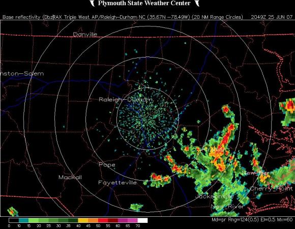
MIKE MOSS SAYS: Doug, I was too late getting to your question to have a look at Doppler 5000, which may have given a higher resolution image of the feature you noticed. However, a check of archived radar imagery from the Raleigh NEXRAD system (NWS Doppler radar located in almost the same place as D5000) clearly picks up on that same feature. I have embedded a few images from that time frame to illustrate what was happeneing. I also had a look at a loop of radar data from the event, and was able to easily trace the westward moving narrow line to outflow from a cluster of strong thunderstorms that formed over eastern Wayne County, Green County and Lenoir County. This cluster drifted slowly southeast, but surface winds were very light and an outflow boundary produced by a downrush of dense, raincooled air as those storms collapsed spread toward the west, in effect producing a shallow "cool front" that propagated westward into and across Wake County. The line became visible as it moved close enough to the Radar site so that the beam no longer passed over top of it. These outflow boundaries are not especially unusual, although they are less organized and less well defined when there are more storms scattered about the area or when there are stronger ambient winds in the lower atmosphere. The reasons the lines become visible on radar are (1) the convergence of winds of differnet speed and direction along the line can concentrate dust and flying insects enough to enhance radar reflectivity there and (2) the boundary between two airmasses having significantly differing temperature and humidity values creates a turbulent mix in which the turbulent variations of density act to reflect radar energy in a process called "Bragg Scattering."
When conditions are right, these outflow boundaries can sometimes act as triggers for additional storm formation because the conversing winds cause upward motion, and sometimes because the cooler, denser air undercuts warm, moist and unstable air and forces it upward. This can be especially notable when there are multiple boundaries present and they intersect.
As for the imagery above, the first shows the remains of the thunderstorms east of Goldsboro, with the boundary line just becoming visible east of Wake County, with the following two images (at one hour intervals) ahowing the line moving farther west with time. The final product is a time section of radar estimated winds with height. Here you can see that before the arrival of the boundary, the Raleigh radar was picking up winds that were from the northwest at several thousand feet above the ground (leading to the southeasterly drift of vertically well-developed storm cells) and west to southwest and very light before the arrival of the boudary. Once it reached the area, the lowest level winds shifted to the southeast.
Copyright 2024 by Capitol Broadcasting Company. All rights reserved. This material may not be published, broadcast, rewritten or redistributed.


