
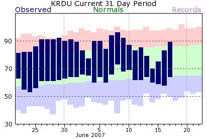
Luckily, it may not last, at least not in extreme form. We had a big break from toasty temperatures last week, with highs that hovered comfortably in the 70s for several days (see the graph in the image, from the Raleigh NWS web site). In fact, it was especially interesting how it all turned out for Thursday. Back on the previous Sunday, I wrote an internal forecast discussion that we use for continuity among the various WeatherCenter folks in which I noted that one of the longer range computer models, the GFS, was giving some signals that we might have a tough time getting past 70 on Thursday. Because the model had one serious difference from most others involving a strong "nor'easter" style low that it was developing near the NC/SC border at that time, I was concerned that if that low did not develop, temperatures would be warmer. So, for the next day or two we held the forecast in the upper 70s for Thursday. In the end, the high that day turned out to be a cool 70 on the nose, just a few degrees above our normal low for the date, but there was no big low spinning along the NC coast. Instead the cool readings were a result of a persistent northeast flow around a deep cutoff low in the northwest Atlantic, and a well-timed "shotwave" trough rotating around the west side of that low that enhanced clouds and precipitation here in such a way as to greatly limit solar heating. A case of that Sunday model being right about the temperature four days later, while being wrong about the reason for it.
Since then, we've seen a gradual development of a Bermuda High ridge at the surface, centered a little to our east and southeast, along with a developing upper level ridge that has drifted our way from the MS valley region. That is usually a prescription for a rapid warmup, and having reached 89 at RDU and 92 at Fayetteville on Father's Day, that's pretty much been the case through the weekend. It now appears we'll top out that warming trend today and tomorrow, and should reach mid to upper 90s this afternoon (our record at RDU is 98) before a slight cooling on Tuesday. Luckily, yesterday and today featured an airmass that isn't all that moist above the lowest few hundred feet, so that as temperatures climb and convective mixing reaches higher and higher above the surface, dry air has mixed down and lowered our dewpoints. On Sunday, dewpoints around sunrise were in the 65-69 degree range, enough to feel a bit muggy and to result in a Heat Index value several degrees above the temperature had it held up. However, that mixing process I mentioned caused the dewpoint to fall into the mid 50s in the afternoon. At those dew point levels, there is no heat index added to the ambient temperature, and 90 degrees, for example, "feels like" 90 degrees. We think that same process is likely today, with dewpoints falling at least into the upper 50s to around 60 for the afternoon, and heat index values only a degree or two above the actual temperature, which will be hot enough as it is!
By Wednesday, a weakening cold front should slide into the region, along with a modest upper level trough to our west, and the combination should reduce temperatures a good bit, especially if we get some scattered showers and storms, which for now appears to be a reasonable prospect. We don't expect widespread, drought-busting rains, but enough clouds and rain to hold us in the 80s, although at this point it doesn't appear we're in for another big cool-down of the sort we saw last week. In fact, we may rebound well into the 90s by next weekend - it will be "summer" by then, after all...
Copyright 2024 by Capitol Broadcasting Company. All rights reserved. This material may not be published, broadcast, rewritten or redistributed.


