
No blog entry here last week as I was away on Air Force Reserve duty - one of the tasks of the unit I work with is to keep the Third Army leadership aware of weather issues and impacts in the Middle East, and last week happened to be a bit of an outlier in that respect. By this time of year, many of the areas of greatest interest have transitioned to a very dry and hot pattern, with dust storms and excessive heat as primary weather factors. Last week, though, there was actually a major tropical cyclone to track, one that moved into a historically unusual position and that, at an earlier point in its life cycle, topped out as a Category 5 storm with sustained winds reaching 140 knots (about 160 mph).
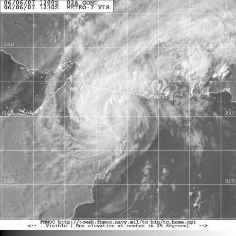
The storm was named Cyclone Gonu. "Cyclone" in the northern Indian Ocean basin is equivalent to the word hurricane or typhoon in other parts of the world, all describing the same type of storm. Gonu (shown above in a visible satellite image from the Naval Research Laboratory's Tropical Cyclone page) ended up moving right into the Gulf of Oman and almost as far west as the Strait of Hormuz, a very unusual location. In fact, as seen in the second image above, from Wikipedia, showing all worldwide tropical cyclone tracks since 1985, it is the only such cyclone to move into the Gulf during that time. I checked some other sources back as far as the late 1960s, and none have entered the Gulf as a Category 1 or higher storm during that lengthy period until now. Most storms in that basin end up recurving to the northeast, or weaken and dissipate out over the Indian Ocean or Arabian Sea, in a few cases moving into the eastern Arabian peninsula as tropical depressions.
In the case of Gonu (seen in a forecast track and a storm history track in the third and fourth images above, from NRL and the Unisys tropical archive sites) the storm was still a Category 2 system as it brushed by the northeastern tip of Oman (with major impacts on that country) and a Category one well into the Gulf, before weakening considerably as it drifted northwest into Iran.
There were considerable concerns at one point regarding impacts on oil facilities in the region and on shipping of oil supples that transit the Strait of Hormuz, leading to a brief price spike in oil markets, but this calmed quickly as it became apparent that the storm would not do as much damage as feared. However, it did have very serious effects in parts of Oman and Iran, with some damage from high winds and seas, and even more so heavy rain bands leading to severe flooding. News reports indicated that at least 25 people were killed in Oman and 3 in Iran. For one such report from the storm, and some raw video of the aftermath in the Omani capital Muscat, see the story at
http://wwwimage.cbsnews.com/stories/2007/06/07/storm/main2896809.shtml
Also, for a much higher resolution version of the Global map above showing tropical cyclone tracks, which nicely visualizes the relative frequency of these storms worldwide, see
http://en.wikipedia.org/wiki/Image:Global_tropical_cyclone_tracks-edit2.jpg
Copyright 2024 by Capitol Broadcasting Company. All rights reserved. This material may not be published, broadcast, rewritten or redistributed.


