
Although the "prime time" for hurricane activity affecting North Carolina runs from about early August to mid October, we have had our share of tropical cyclone impacts during June and July, so with the arrival of the 2007 Atlantic Hurricane Season coming up this Friday (June 1st) it's probably worth a quick review of what's anticipated in the way of Atlantic activity this year, and some awareness and preparation actions that we all can take to be ready in case we end up with a significant strike or two in our region.
Most of the groups that make an effort to forecast the number of tropical cyclones each season are in resonable agreement this year that a very active season is likely - while we may not reach the numbers seen in the incredible 2005 hurricane season, the forecasts that are out for this year do indicate well above normal levels. Taking a look at three sources of seasonal forecasts, we have NOAA projecting 13-17 named storms and 7-10 hurricanes, while Dr William Gray's group at Colorado State University expects 17 named storms and 9 hurricanes. An NCSU team led by Dr Lian Xie also expects an above normal season for 2007, calling in a recent press release for 12-14 named storms and 8-9 hurricanes.These numbers compare to long-term averages of 10 named storms and 6 hurricanes.
Last year, an above normal season was also predicted by NOAA and Dr Gray's teams, while the NCSU team predicted a much less active season, and came rather close to the observed numbers of 9 named storms and 5 hurricanes for 2006, which turned out to be a near normal year in part because of the rapid onset of an unexpected El Nino pattern in the Pacific. While climate forecasters have had resonably good success in the last decade or so of predicting the onset and dissipation of El Nino and La Nina, this one snuck up in a hurry. Because of downstream influences in which El Nino tends to enhance vertical wind shear across the Atlantic hurricane formation regions, El Nino years are associated with a tendency toward below normal Atlantic hurricane activity, while the reverse holds true as La Nina years tend to correlate with reduced vertical shear in the Atlantic and enhanced numbers of tropical cyclones.
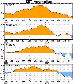
That could be an important factor in this year's season, along with above normal Atlantic sea surface temperatures, as the moderate El Nino that developed so quickly last year likewise faded in a hurry earlier this year. Since then, we have seen a neutral pattern in the Pacific. Sometimes, these patterns, characterized by ocean temperatures over the central and eastern equatorial Pacific that are fairly close to long term averages as opposed to above normal for El Nino and below normal for La Nina, can last a reasonably long time, but often there is a fairly fast transition to the next La Nina or El nino episode. This year, most of the long range prediction experts are leaning towward a full-fledged La Nina pattern setting in sometime between now and late July or so. Two of the regions that are tracked to diagnose the current state of the Pacific are already showing noticeable negative temperature anomalies, as seen in the first graphic above from the Climate Prediction Center (for more of their El Nino-Southern Oscillation imagery and discussions, see http://www.cpc.ncep.noaa.gov/products/precip/CWlink/MJO/enso.shtml). You can see the development of El Nino last year, as temperatures in all the regions rapidly rose by early summer, and then the decline in sea surface temperatures is likewise evident over the past few months. The second graphic is a different way of looking at the data, showing average water temperatures near the equator from the western Pacific to the eastern Pacific along the horizontal axis, and the changes with time over the past year or so from top to bottom, so that again you can see more broadly the warmup and subsequent cooling of the central and eastern Pacific.
With all that in mind, and potential for an active hurricane season, not to mention the fact that even an inactive season can be a major headache if one or two fo the few storms tracks across your location, you might like to review some background information and preparedness guidance that the National weather Service publicized during last week's "Hurricane Awareness Week." While we covered some of these topics briefly on the air at times, you can find more detail on these National Hurricane Center and State of NC web sites:
http://www.nhc.noaa.gov/HAW2/english/intro.shtml
http://www.readync.org/index.cfm?espanol=0&topic=27&on=Hurricane
Copyright 2024 by Capitol Broadcasting Company. All rights reserved. This material may not be published, broadcast, rewritten or redistributed.


